Approximate Location Map
Large Map »
Latitude: 53.4097 / 53°24'34"N
Longitude: -1.021 / 1°1'15"W
OS Eastings: 465173
OS Northings: 390766
OS Grid: SK651907
Mapcode National: GBR PY90.RF
Mapcode Global: WHFFV.9K1F
Plus Code: 9C5WCX5H+VH
Entry Name: The Old Vicarage
Listing Date: 1 February 1967
Grade: II
Source: Historic England
Source ID: 1239432
English Heritage Legacy ID: 417316
ID on this website: 101239432
Location: Scrooby, Bassetlaw, Nottinghamshire, DN10
County: Nottinghamshire
District: Bassetlaw
Civil Parish: Scrooby
Traditional County: Nottinghamshire
Lieutenancy Area (Ceremonial County): Nottinghamshire
Church of England Parish: Scrooby with Ranskill
Church of England Diocese: Southwell and Nottingham
Tagged with: Clergy house
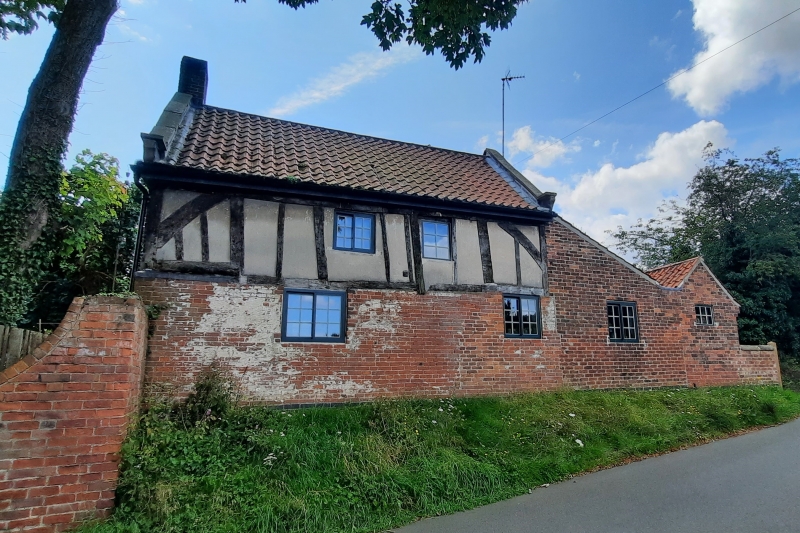
SK 69 SE SCROOBY CHURCH ROAD
(south side)
1/116 The Old Vicarage
1.2.67
G.V. II
House, c.1600, C18 and C20 with C20 renovations. Ground floor
C18 red brick with a C20 blue brick band at the base. 1st floor
timber frame and plaster. Pantile roof with C20 stone coped
gables and kneelers, single left brick gable stack and single
projecting stack to the rear right. 2 storeys, 2 bays, with
single long and short bays. 2 sliding sashes with lozenge
shaped panes. Above, a similar single sash and to the right a
single casement with similar panes. To the right is a later
brick and pantile lean-to with a similar sliding sash, further
right is the gable end of a later brick and pantile single storey
extension with single fixed light. To the rear is a single
storey 2 bay C20 extension contructed from older materials.
Interior. Ground floor left/long bay has C18 panelling,
installed c.1900. There is also an C18 bressumer fireplace with
small inglenook glazing bar fixed light. The 1st floor tie
beams exist, but have been drawn in and have mortices instead of
braces. In the apex of the roof between the long and short bays
is a stud partition.
Listing NGR: SK6517390766
External links are from the relevant listing authority and, where applicable, Wikidata. Wikidata IDs may be related buildings as well as this specific building. If you want to add or update a link, you will need to do so by editing the Wikidata entry.


Other nearby listed buildings
