Approximate Location Map
Large Map »
Latitude: 51.1203 / 51°7'13"N
Longitude: 0.1887 / 0°11'19"E
OS Eastings: 553272
OS Northings: 137944
OS Grid: TQ532379
Mapcode National: GBR MPW.LK2
Mapcode Global: VHHQK.733J
Plus Code: 9F3245CQ+4F
Entry Name: Roadside Horse Trough and Drinking Fountain
Listing Date: 24 August 1990
Grade: II
Source: Historic England
Source ID: 1240714
English Heritage Legacy ID: 439222
ID on this website: 101240714
Location: Groombridge, Tunbridge Wells, Kent, TN3
County: Kent
District: Tunbridge Wells
Civil Parish: Speldhurst
Traditional County: Kent
Lieutenancy Area (Ceremonial County): Kent
Church of England Parish: Speldhurst St Mary the Virgin
Church of England Diocese: Rochester
Tagged with: Manger
TQ 53 37 SPELDHURST GROOMBRIDGE HILL (west side),
OLD GROOMBRIDGE
16/517 Roadside horse trough and
drinking fountain
GV II
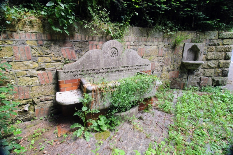
Horse trough and drinking fountain. Dated 1894 and erected in memory of
William Coston Oswell who built the Norman Shaw house, Hillside (q.v.) further
up the hill. Polished grey limestone with some glazed red brick. Both are
set into a coursed sandstone wall revetting the hillside. They are set
alongside the road up Groombridge Hill facing south. The trough is supported
on 2 piers of glazed brick. It is set in front of a back piece built of brick
up as high as the rim and is surmounted by a large limestone panel with
curvilinear shaped head. In the centre a vesica-shaped panel is scribed with
the date 1894 above an inscription in capital letters commemorating William
Coston Oswell. There are stone shelves each side of the trough. Nearby, to
right, is the drinking fountain which is built in the style of an
ecclesiastical piscina with a trefoil-headed niche and projecting bowl on
moulded base.
This horse trough and drinking fountain form part of the important group of
listed buildings in the vicinity of Groombridge Place (q.v.) and Old
Groombridge village.
Listing NGR: TQ5327237944
External links are from the relevant listing authority and, where applicable, Wikidata. Wikidata IDs may be related buildings as well as this specific building. If you want to add or update a link, you will need to do so by editing the Wikidata entry.


Other nearby listed buildings
