Approximate Location Map
Large Map »
Latitude: 51.2815 / 51°16'53"N
Longitude: 1.0818 / 1°4'54"E
OS Eastings: 615016
OS Northings: 158108
OS Grid: TR150581
Mapcode National: GBR TY2.Q9Y
Mapcode Global: VHLGM.P1RX
Plus Code: 9F3373JJ+JP
Entry Name: 24 and 25, Palace Street
Listing Date: 3 May 1967
Grade: II
Source: Historic England
Source ID: 1241502
English Heritage Legacy ID: 440569
ID on this website: 101241502
Location: Canterbury, Kent, CT1
County: Kent
District: Canterbury
Electoral Ward/Division: Westgate
Parish: Non Civil Parish
Built-Up Area: Canterbury
Traditional County: Kent
Lieutenancy Area (Ceremonial County): Kent
Tagged with: Building
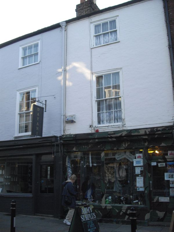
1.
944 PALACE STREET
(West Side)
Nos 24 and 25
TR 1558 SW 3/285 3.5.67.
II GV
2.
C18 pair. 3 storeys painted brick. Hipped tiled roof. Rainwater hood. 1
sash set in moulded architrave with glazing bars intact. The ground floor
has early C19 shop fronts with pilastered door surrounds.
Church of St Alphege and Nos 10 to 28 (consec) form a group.
Listing NGR: TR1501258108
External links are from the relevant listing authority and, where applicable, Wikidata. Wikidata IDs may be related buildings as well as this specific building. If you want to add or update a link, you will need to do so by editing the Wikidata entry.


Other nearby listed buildings
