Approximate Location Map
Large Map »
Latitude: 51.2839 / 51°17'2"N
Longitude: 1.0712 / 1°4'16"E
OS Eastings: 614264
OS Northings: 158342
OS Grid: TR142583
Mapcode National: GBR TY2.FN1
Mapcode Global: VHLGF.JZ4N
Plus Code: 9F3373MC+HF
Entry Name: 34 and 35, St Dunstan's Street
Listing Date: 7 September 1973
Grade: II
Source: Historic England
Source ID: 1241845
English Heritage Legacy ID: 441034
ID on this website: 101241845
Location: St Dunstan's, Canterbury, Kent, CT2
County: Kent
District: Canterbury
Electoral Ward/Division: St Stephen's
Parish: Non Civil Parish
Built-Up Area: Canterbury
Traditional County: Kent
Lieutenancy Area (Ceremonial County): Kent
Tagged with: Building
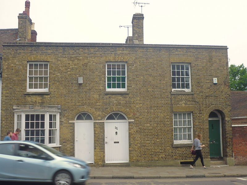
1.
944 ST DUNSTAN'S STREET
(North East Side)
Nos 34 & 35
TR 1458 SW 1/654
II GV
2.
Early C19. 2 storeys buff brick. Hipped slate roof 3 sashes with glazing
bars intact with brick heads and stone cills. Ground floor has 3 light bay
and 2 round-headed doorcases with fanlights. Central passageway.
Nos 34 to 38 (consec) together with Nos 2 to 8 (consec) Whitstable Road form a group.
Listing NGR: TR1427158343
External links are from the relevant listing authority and, where applicable, Wikidata. Wikidata IDs may be related buildings as well as this specific building. If you want to add or update a link, you will need to do so by editing the Wikidata entry.


Other nearby listed buildings
