Approximate Location Map
Large Map »
Latitude: 51.2817 / 51°16'53"N
Longitude: 1.0752 / 1°4'30"E
OS Eastings: 614556
OS Northings: 158104
OS Grid: TR145581
Mapcode National: GBR TY2.NMR
Mapcode Global: VHLGM.L18T
Plus Code: 9F3373JG+M3
Entry Name: 93, St Dunstan's Street
Listing Date: 3 December 1949
Grade: II
Source: Historic England
Source ID: 1241976
English Heritage Legacy ID: 441180
ID on this website: 101241976
Location: Canterbury, Kent, CT2
County: Kent
District: Canterbury
Electoral Ward/Division: Westgate
Parish: Non Civil Parish
Built-Up Area: Canterbury
Traditional County: Kent
Lieutenancy Area (Ceremonial County): Kent
Tagged with: Building
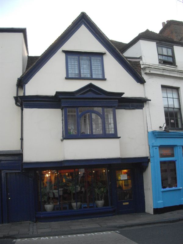
1.
944 ST DUNSTAN'S STREET
(South West Side)
No 93
TR 1458 SE 2/123 3.12.49.
II GV
2.
Late C16 to early C17 timber framed house with gable end. 2 storeys and gable
plastered. Tiled roof. 1 casement in gable, lst floor has a late C17 bay
with round-headed centre, Later C19 shopfront. Overhang. Thick cornice
and pediment over lst floor bay.
Nos 87 to 95 (consec), Garden Wall & gate piers to No 87 form a group.
Listing NGR: TR1455458101
External links are from the relevant listing authority and, where applicable, Wikidata. Wikidata IDs may be related buildings as well as this specific building. If you want to add or update a link, you will need to do so by editing the Wikidata entry.


Other nearby listed buildings
