Approximate Location Map
Large Map »
Latitude: 51.1633 / 51°9'47"N
Longitude: 0.1771 / 0°10'37"E
OS Eastings: 552322
OS Northings: 142698
OS Grid: TQ523426
Mapcode National: GBR MP8.X6F
Mapcode Global: VHHQC.01Z2
Plus Code: 9F32557G+8R
Entry Name: Cartshed Adjoining Road to North of South Park Farmhouse
Listing Date: 16 January 1975
Grade: II*
Source: Historic England
Source ID: 1243096
English Heritage Legacy ID: 446431
ID on this website: 101243096
Location: Penshurst, Sevenoaks, Kent, TN11
County: Kent
District: Sevenoaks
Civil Parish: Penshurst
Traditional County: Kent
Lieutenancy Area (Ceremonial County): Kent
Church of England Parish: Penshurst St John the Baptist
Church of England Diocese: Rochester
Tagged with: Carriage house
In the entry for;
TQ 54 SW PENSHURST SMARTS HILL
54/868 (Westside)
GV Shelter sheds on North side of
South Park Farmyard
II
The entry shall be amended to read;
TQ 54 SW PENSHURST SMARTS HILL
54/868 (Westside)
GV Cartshed adjoining road to North
of South Park Farmhouse
II*
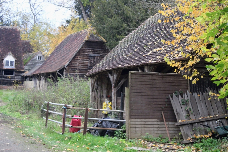
Cart shed 1850-1 as part of farmstead designed by George Devey. Weatherboard
over timber frame; half-hipped tile roof. 3 bays. Loft door over gable end
facing south. Slender arch bracing to wall plate and wall posts. Interior not inspected. Part of a picturesque group of exceptional importance, one of the earliest works of George Devey whose vernacular revival work "marked a
milestone in nineteenth century architecture (M Girovard, The Victorian
Country House).
------------------------------------
1.
5280 PENSHURST SMARTS HILL
(West Side)
Shelter Sheds on North
side of South Park Farmyard
TQ 54 SW 54/868
II GV
2.
Mid C19. 2 3-bay,weatherboarded shelter sheds with open fronts and half
hipped tiled roofs, at right angles to each other.
South Park Farmhouse and attached barn. Range of buildings at East end of farmyard and shelter sheds on North side of Farmyard form a group.
Listing NGR: TQ5232242698
External links are from the relevant listing authority and, where applicable, Wikidata. Wikidata IDs may be related buildings as well as this specific building. If you want to add or update a link, you will need to do so by editing the Wikidata entry.


Other nearby listed buildings
