Latitude: 51.2844 / 51°17'3"N
Longitude: 0.1671 / 0°10'1"E
OS Eastings: 551228
OS Northings: 156143
OS Grid: TQ512561
Mapcode National: GBR S9.YLT
Mapcode Global: VHHPK.VZ69
Plus Code: 9F3275M8+PV
Entry Name: 48 and 50, Chipstead Lane
Listing Date: 16 January 1975
Grade: II
Source: Historic England
Source ID: 1243289
English Heritage Legacy ID: 446974
ID on this website: 101243289
Location: Riverhead, Sevenoaks, Kent, TN13
County: Kent
District: Sevenoaks
Civil Parish: Riverhead
Built-Up Area: Sevenoaks
Traditional County: Kent
Lieutenancy Area (Ceremonial County): Kent
Church of England Parish: Riverhead St Mary
Church of England Diocese: Rochester
Tagged with: Building
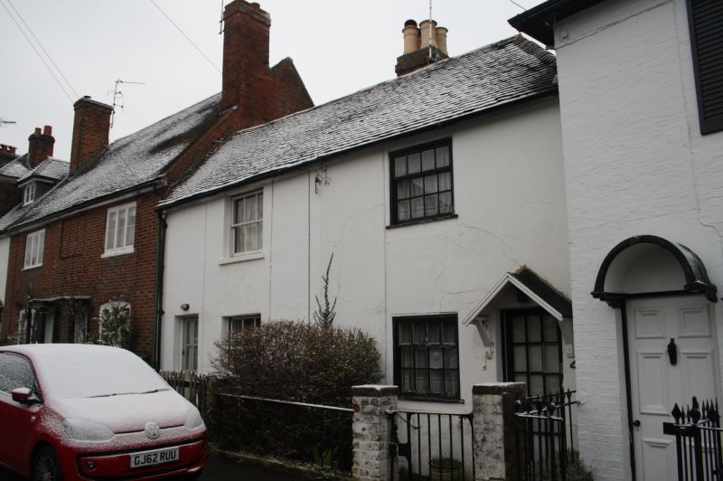
1.
5280 RIVERHEAD RIVERHEAD
Chipstead Lane
(North Side)
Nos 48 & 50
TQ 5156 25/956
II GV
2.
Pair of late C18 or early C19 cottages, each 2 storeys, one window. Tiled roof
hipped at right. Rendered facade with incised lines. Sash windows with glazing
bars in painted reveals. Plain doors.
Nos 40 to 62 (even) form a group.
Listing NGR: TQ5122856143
External links are from the relevant listing authority and, where applicable, Wikidata. Wikidata IDs may be related buildings as well as this specific building. If you want to add or update a link, you will need to do so by editing the Wikidata entry.


Other nearby listed buildings