Approximate Location Map
Large Map »
Latitude: 53.6852 / 53°41'6"N
Longitude: -1.5016 / 1°30'5"W
OS Eastings: 433012
OS Northings: 421083
OS Grid: SE330210
Mapcode National: GBR KTYT.PP
Mapcode Global: WHC9Z.XM3R
Plus Code: 9C5WMFPX+39
Entry Name: 20, RISHWORTH STREET (See details for further address information)
Listing Date: 22 March 1988
Grade: II
Source: Historic England
Source ID: 1243433
English Heritage Legacy ID: 446834
ID on this website: 101243433
Location: Wakefield, West Yorkshire, WF1
County: Wakefield
Electoral Ward/Division: Wakefield North
Parish: Non Civil Parish
Built-Up Area: Wakefield
Traditional County: Yorkshire
Lieutenancy Area (Ceremonial County): West Yorkshire
Church of England Parish: Wakefield St John the Baptist
Church of England Diocese: Leeds
Tagged with: Building
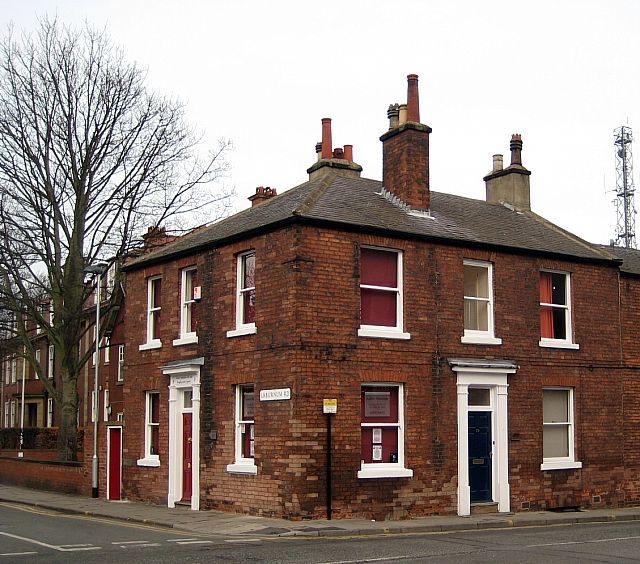
1. RISHWORTH STREET
5115 (north-west side)
SE 3321 No. 20 and No. 2
4/301 Laburnum Road
II
GV
2.
Two houses. c 1840. Red-brown brick in irregular Flemish garden wall bond,
Welsh slate roof. 2 storeys, 3 x 3 bays. Each has step up to central doorway
having overlight and wooden doorcase with pilasters, frieze and cornice (frieze
and cornice of No. 2's doorcase removed). No 20 has a 6-panel door (upper panels
raised and fielded), No. 2 a C20 board door. Windows have slightly cambered
brick arches, projecting stone sills and 2-pane sashes; No 20's central lst-
floor window bricked up, and those of No. 2 apart from left-hand bay; top of
cellar windows of No. 20 visible. Roof hipped over No. 2 with stacks at right
end of No. 20, in front roof slope of No. 20 and in line with this in rear roof
slope.
Shown on the 1848 Wakefield plan.
Included for group value only.
Listing NGR: SE3301221083
External links are from the relevant listing authority and, where applicable, Wikidata. Wikidata IDs may be related buildings as well as this specific building. If you want to add or update a link, you will need to do so by editing the Wikidata entry.


Other nearby listed buildings
