Approximate Location Map
Large Map »
Latitude: 54.4662 / 54°27'58"N
Longitude: -2.3382 / 2°20'17"W
OS Eastings: 378179
OS Northings: 507926
OS Grid: NY781079
Mapcode National: GBR DJ3S.LR
Mapcode Global: WH93G.1ZWZ
Plus Code: 9C6VFM86+FP
Entry Name: Pod Gill Viaduct
Listing Date: 22 December 1995
Grade: II
Source: Historic England
Source ID: 1243976
English Heritage Legacy ID: 448530
ID on this website: 101243976
Location: Hartley, Westmorland and Furness, Cumbria, CA17
County: Cumbria
District: Eden
Civil Parish: Hartley
Built-Up Area: Kirkby Stephen
Traditional County: Westmorland
Lieutenancy Area (Ceremonial County): Cumbria
Church of England Parish: Kirkby Stephen with Mallerstang and Crosby Garrett with Soulby
Church of England Diocese: Carlisle
The asset was previously listed twice also under List entry 1096036. This entry was removed from the List on 23 November 2016.
This list entry was subject to a Minor Amendment on 2 November 2016.
NY 6070,
37-/6/10002
HARTLEY,
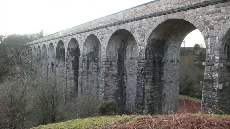
Pod Gill Viaduct
II
Railway Viaduct. Built in 1861, widened 1889, for the South Durham and Lancashire Union Railway (North-Eastern Railway) to span the valley of the Ladthwaite Beck. Engineer Thomas Bouch, contractors Chambers and Hilton. Opened as a single line structure in August 1861, and doubled in width in 1889. Constructed of snecked and coursed squared rubble sandstone, with rusticated voussoirs and finely jointed ashlar soffits. The south-east line is of larger block than the north-west. A straight viaduct, 466 feet in length, and incorporating 11 semi-circular headed arches, each 30 feet wide. The Viaduct is 84 feet high at its tallest point, and is carried by tall, tapered rectangular piers, with 2 rows of corbels at the heads of the piers formerly used to support constructional formwork for the arches. Parapets rise from moulded courses above arch heads and terminate at plain ashlar parapets. Splayed abutments with shallow pilasters to side walls, terminating at rectangular upstands With shallow pyramidal caps. At the time of widening, refuges of unusual design were created in the thickness of the walls, and shielded on the outsides by cast-iron plates shaped to the profile of the copings. There are 4 such refuges on the south-east side, and 3 to the north-east. A dramatically set viaduct by a notable bridge engineer, of particular interest as an example of a widened structure, the 2 phases displaying different constructional characteristics.
Listing NGR: NY 78179 07926
External links are from the relevant listing authority and, where applicable, Wikidata. Wikidata IDs may be related buildings as well as this specific building. If you want to add or update a link, you will need to do so by editing the Wikidata entry.


Other nearby listed buildings
