Approximate Location Map
Large Map »
Latitude: 51.2521 / 51°15'7"N
Longitude: -0.9364 / 0°56'10"W
OS Eastings: 474325
OS Northings: 150861
OS Grid: SU743508
Mapcode National: GBR C86.J2G
Mapcode Global: VHDXS.QSBJ
Plus Code: 9C3X7327+RC
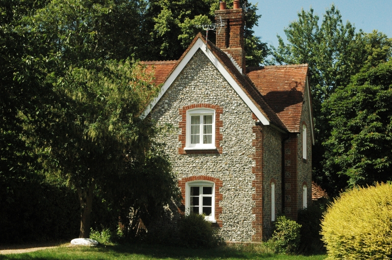
Entry Name: Cemetery Lodge
Listing Date: 26 June 1987
Grade: II
Source: Historic England
Source ID: 1244357
English Heritage Legacy ID: 449404
ID on this website: 101244357
Location: Odiham, Hart, Hampshire, RG29
County: Hampshire
District: Hart
Civil Parish: Odiham
Built-Up Area: Odiham
Traditional County: Hampshire
Lieutenancy Area (Ceremonial County): Hampshire
Church of England Parish: Odiham All Saints
Church of England Diocese: Winchester
Tagged with: Gatehouse
SU 73-7450 & 73-7451 ODIHAM KING STREET
(East Side)
17/125 Cemetery Lodge
-
GV II
1860. 2 storeyed house with gabled facades. Red tile roofing: 2 Tudor brick
stacks. Flint walls with red brick quoins, cambered openings, plinth.
Casements. Plain door, with tile roof single-pitched canopy on brackets.
Date plaque.
Listing NGR: SU7411251055
External links are from the relevant listing authority and, where applicable, Wikidata. Wikidata IDs may be related buildings as well as this specific building. If you want to add or update a link, you will need to do so by editing the Wikidata entry.


Other nearby listed buildings
