Approximate Location Map
Large Map »
Latitude: 54.4452 / 54°26'42"N
Longitude: -2.9787 / 2°58'43"W
OS Eastings: 336626
OS Northings: 505970
OS Grid: NY366059
Mapcode National: GBR 7KM1.X9
Mapcode Global: WH826.6JTM
Plus Code: 9C6VC2WC+3G
Entry Name: Pelter Bridge
Listing Date: 15 March 1974
Grade: II
Source: Historic England
Source ID: 1245484
English Heritage Legacy ID: 452641
ID on this website: 101245484
Location: Rydal, Westmorland and Furness, Cumbria, LA22
County: Cumbria
District: South Lakeland
Civil Parish: Lakes
Traditional County: Westmorland
Lieutenancy Area (Ceremonial County): Cumbria
Church of England Parish: Rydal St Mary
Church of England Diocese: Carlisle
Tagged with: Bridge
1.
1291A RYDAL AND LOUGHRIGG
RYDAL
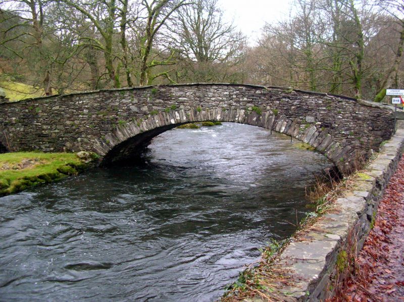
Pelter Bridge
NY 30 NE 9/187
II GV
2.
Date uncertain Stone rubble 3-centred arch and a small flood arch with
slate parapet, narrow, humped. Very picturesque feature in parkland landscape.
For group notes see General group description under Rydal.
Listing NGR: NY3662605970
External links are from the relevant listing authority and, where applicable, Wikidata. Wikidata IDs may be related buildings as well as this specific building. If you want to add or update a link, you will need to do so by editing the Wikidata entry.


Other nearby listed buildings
