Latitude: 51.8989 / 51°53'56"N
Longitude: -2.0663 / 2°3'58"W
OS Eastings: 395534
OS Northings: 222267
OS Grid: SO955222
Mapcode National: GBR 2M5.SJ7
Mapcode Global: VHB1Q.4JHM
Plus Code: 9C3VVWXM+HF
Entry Name: Numbers 79 and 81 and Atached Railings
Listing Date: 5 May 1972
Grade: II
Source: Historic England
Source ID: 1245595
English Heritage Legacy ID: 474717
ID on this website: 101245595
Location: Fairview, Cheltenham, Gloucestershire, GL52
County: Gloucestershire
District: Cheltenham
Electoral Ward/Division: All Saints
Parish: Non Civil Parish
Built-Up Area: Cheltenham
Traditional County: Gloucestershire
Lieutenancy Area (Ceremonial County): Gloucestershire
Church of England Parish: Cheltenham St Luke and St John
Church of England Diocese: Gloucester
Tagged with: Building
CHELTENHAM
SO9522SE HEWLETT ROAD 630-1/15/388 (East side) 05/05/72 Nos.79 AND 81 and attached railings
GV II
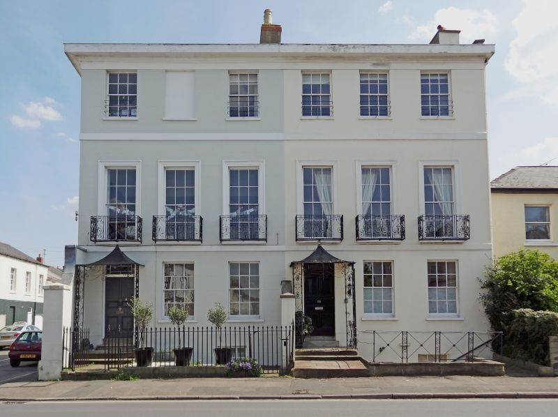
2 terraced houses and attached railings. c1820-34, shown as built on Merrett's 1834 Map. Stucco over brick with brick and stucco end and party-wall stacks and concealed roof with iron balconies, tent porches and railings. Double-depth plan with 2-low-storey service wings to rear. EXTERIOR: 3 storeys with basement, 6 first-floor windows (3:3). Stucco details include first- and second-floor plat bands, frieze and cornice. 6/6 sashes throughout, taller to first floor and with tooled architraves (blind to second floor, second window), all in plain reveals and with sills. Entrances at left, 6-fielded-panel doors with overlights. Left return has 3 blind openings per floor. Rear has some 6/6 sashes. INTERIOR: not inspected. SUBSIDIARY FEATURES: first-floor individual balconies have ogeed scroll motif; bars to second-floor windows. Lancet area railings and gates to left, X-motif balustrade with scroll band to right. Porches have scrolled uprights and openwork friezes with reverse teardrop motif. HISTORICAL NOTE: known as Hewlett Street on Merrett's Map.
Listing NGR: SO9553822263
External links are from the relevant listing authority and, where applicable, Wikidata. Wikidata IDs may be related buildings as well as this specific building. If you want to add or update a link, you will need to do so by editing the Wikidata entry.


Other nearby listed buildings