Approximate Location Map
Large Map »
Latitude: 53.2185 / 53°13'6"N
Longitude: -1.6777 / 1°40'39"W
OS Eastings: 421614
OS Northings: 369099
OS Grid: SK216690
Mapcode National: GBR 57S.8MX
Mapcode Global: WHCD7.6CBG
Plus Code: 9C5W689C+CW
Entry Name: Summerhouse at Holme Hall with Attached Walled Enclosure
Listing Date: 20 May 1974
Last Amended: 5 December 1997
Grade: II
Source: Historic England
Source ID: 1246170
English Heritage Legacy ID: 468147
ID on this website: 101246170
Location: Bakewell, Derbyshire Dales, Derbyshire, DE45
County: Derbyshire
District: Derbyshire Dales
Civil Parish: Bakewell
Built-Up Area: Bakewell
Traditional County: Derbyshire
Lieutenancy Area (Ceremonial County): Derbyshire
Church of England Parish: Bakewell All Saints
Church of England Diocese: Derby
Tagged with: Summer house Garden house
BAKEWELL
SK2169 HOLME LANE
831-1/3/107 (North side (off))
20/05/74 Summerhouse at Holme Hall with
attached walled enclosure
(Formerly Listed as:
HOLME
(North side)
Court House at Holme Hall)
GV II
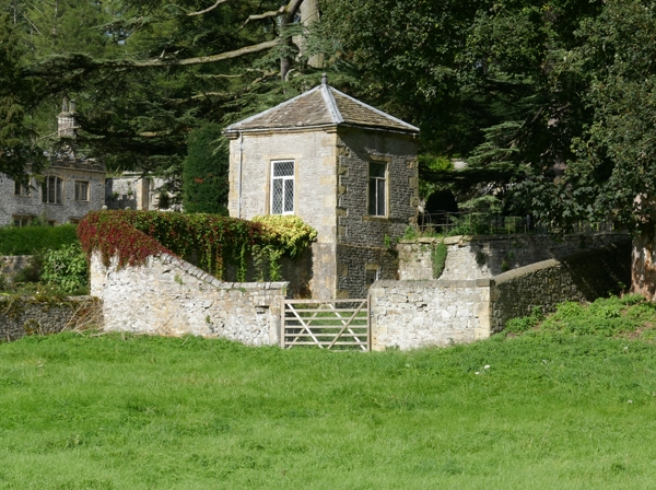
Summerhouse, formerly used as courthouse, with attached walled
enclosure. Late C17; enclosure walling probably C18. Coursed
limestone with ashlar sandstone dressings; stone slate roof.
Rubble-walled enclosure. Square single-cell.
EXTERIOR: one storey with half-basement; small enclosure
attached to south side. Large quoins. 6-panel door into
half-basement on south side. Upper floor, facing Holme Hall
(qv), has a chamfered, quoined doorway with imposts and
keystone to round arch over part-glazed double doors with
fanlight. Other 3 sides have leaded lights to C20 wooden
casements in bonded ashlar surrounds. Eaves cornice breaks
forward at each corner of hipped roof; ball finial at apex.
INTERIOR: not inspected.
Walled enclosure: dressed sandstone copings which ramp down to
a broad entrance into field to south; the wall is included for
group value.
Listing NGR: SK2161469099
External links are from the relevant listing authority and, where applicable, Wikidata. Wikidata IDs may be related buildings as well as this specific building. If you want to add or update a link, you will need to do so by editing the Wikidata entry.


Other nearby listed buildings
