Approximate Location Map
Large Map »
Latitude: 53.1379 / 53°8'16"N
Longitude: -1.5562 / 1°33'22"W
OS Eastings: 429784
OS Northings: 360174
OS Grid: SK297601
Mapcode National: GBR 58X.9CF
Mapcode Global: WHCDP.2D68
Plus Code: 9C5W4CQV+5G
Entry Name: Matlock Bridge (Over River Derwent)
Listing Date: 22 June 1950
Grade: II*
Source: Historic England
Source ID: 1247890
English Heritage Legacy ID: 429292
ID on this website: 101247890
Location: Matlock Bridge, Derbyshire Dales, Derbyshire, DE4
County: Derbyshire
District: Derbyshire Dales
Civil Parish: Matlock Town
Built-Up Area: Matlock
Traditional County: Derbyshire
Lieutenancy Area (Ceremonial County): Derbyshire
Church of England Parish: Matlock St Giles
Church of England Diocese: Derby
Tagged with: Road bridge
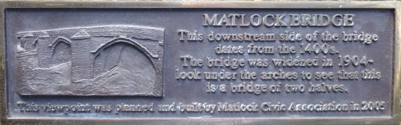
1. DALE ROAD
1390 MATLOCK
Matlock Bridge
(over River Derwent)
SK 26 SE 10/27 22.6.50.
II*
2.
C15. 4 pointed arches with massive cut-waters. V-shaped recessed on one
side only. Restored and widened 1904. AM.
Listing NGR: SK2978460174
External links are from the relevant listing authority and, where applicable, Wikidata. Wikidata IDs may be related buildings as well as this specific building. If you want to add or update a link, you will need to do so by editing the Wikidata entry.


Other nearby listed buildings
