Latitude: 54.9897 / 54°59'23"N
Longitude: -2.6033 / 2°36'11"W
OS Eastings: 361497
OS Northings: 566293
OS Grid: NY614662
Mapcode National: GBR BB8R.63
Mapcode Global: WH90S.ZVJ5
Plus Code: 9C6VX9QW+VM
Entry Name: Birdoswald Farmhouse
Listing Date: 5 March 1990
Grade: II
Source: Historic England
Source ID: 1249314
English Heritage Legacy ID: 78182
ID on this website: 101249314
Location: Upper Denton, Cumberland, Cumbria, CA8
County: Cumbria
District: Carlisle
Civil Parish: Waterhead
Traditional County: Cumberland
Lieutenancy Area (Ceremonial County): Cumbria
Church of England Parish: Lanercostwith Kirkcambeck St Mary Magdalene
Church of England Diocese: Carlisle
Tagged with: Farmhouse
NY 66 NW WATERHEAD BIRDOSWALD
27/104 Birdoswald Farmhouse
(or Birdoswald Tenement)
II
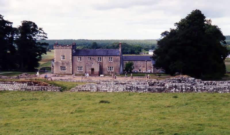
Former farmhouse, now (1988) HQ of the archaeological unit excavating the adjacent
Roman site. Substantially the house built by Henry Norman in 1858, but
incorporating extensive remnants of an earlier building, possibly C15 or early
C16 and perhaps erected by the de Vaux family. Coursed rubble masonry, rendered
on all but the rear (N) elevation; Welsh slate roofs. Plan and development: The
building consists of a principal range aligned E-W, 2-rooms deep (main living rooms
to the S, scullery and other service rooms to the N), entered from the S by a
central porch; attached to this range to the W is a 2-storey tower which appears
to be an almost entirely C19 construction in the form of a tower-house. A now
internal dated lintel in the principal range between the service rooms and the
entrance hall (AQMB1745, commemorating Anthony and Margaret Bowman) and a blocked
window, strongly suggests that this range was originally only a single room in
depth, and extended in 1858. The rear wall of the SE room, and that to the W of
the room and dividing it from the entrance hall are extremely thick and contain
features that confirm an early date: a four-centred stone doorway arch, partially
blocked but visible in the entrance hall; the remains of a newel stair in the SW
corner of the room; and an early (but undateable) window in the rear wall, 1st
floor, and now blocked. These features together suggest the possibility that the
SW room was once a tower-house, but the presence of a high quality doorway at ground
level militates against this (although it is possible that the ground level may
have been altered). A C19 engraving shows that there was no tower to the W before
1858; however the external stack visible on the E wall of the tower evidently pre-
dates the 1858 work for its extensive corbel table survives and is visible in the
roof space. (It may have served as a corbelled fireplace, but this seems unlikely
in this position). Exterior: S elevation: symmetrical 4-window range with
castellated gabled porch containing datestone HN 1858 under small single-light
window. Square-headed doorway with chamfered surround. 2-light windows to 1st
floor with chamfered and vermiculated mullions and surrounds, and 2-pane hornless
sash windows. 3-light window to either side of porch, otherwise treated identically
to those above. Stone coping and internal end stack (with 3 brick shafts) to E
wall, with one C20 window. Rear (N) elevation of principal range with C19
fenestration; 3-window range, the right-hand (W) windows set well to the W; 8-pane
harnless sash windows throughout (altered to ground floor, left). Stone plain
surrounds. One doorway to left, another blocked right of centre. Tower: rendered,
except for N elevation and battlements, the render out back at the angles to
resemble quoining. 2 stages, the upper stage slight recessed. Battlements corbelled
out with external stacks to E and W. S side with one window to each floor, 2 lights
to 1st floor, 3 to ground, with plain chamfered mullions and surrounds. W side
with 2 2-pane hornless sash windows to 1st floor and a narrow slit to external
stack at the same level, all with stone surrounds. Centrally placed shield to
battlements. N: 2 pane harnless sash window to 1st floor; lean to with stone
coping, the door, C19 and studded. Interior: many early features probably remain
under the plaster. 4-centred doorway, remains of newel, and old window (with wooden
lintel) mentioned above. Otherwise standard c19 furnishings; one stone fireplace,
Cl9 but in C16 style. Roof: standard tie, ridge-piece, side purlin roof, difficult
to date but pre-1858. The corbelling in the W gable indicates an ancient well
at this point, date not known (see above).
Note: The C19 owner (Henry Norman) was an antiquerian and conducted his own
excavation of the adjacent Roman site. This 'tower house' (to the W) is an
interesting example of 'medieval reconstruction', although it is possible that
some archaeological evidence indicated the presence of a tower here, and that the
surviving C16 work represents the remains of a hall range. Birdoswald Farmhouse
also indicates the long-established and continuous occupation of this site from
Roman times.
Listing NGR: NY6149766293
External links are from the relevant listing authority and, where applicable, Wikidata. Wikidata IDs may be related buildings as well as this specific building. If you want to add or update a link, you will need to do so by editing the Wikidata entry.


Other nearby listed buildings