Latitude: 51.7446 / 51°44'40"N
Longitude: -0.5531 / 0°33'11"W
OS Eastings: 499988
OS Northings: 206089
OS Grid: SP999060
Mapcode National: GBR F5C.JZP
Mapcode Global: VHFS4.CDFY
Plus Code: 9C3XPCVW+RP
Entry Name: Farm Buildings at Bottom Farm
Listing Date: 26 June 1986
Grade: II
Source: Historic England
Source ID: 1249631
English Heritage Legacy ID: 355492
ID on this website: 101249631
Location: Dacorum, Hertfordshire, HP4
County: Hertfordshire
District: Dacorum
Civil Parish: Berkhamsted
Traditional County: Hertfordshire
Lieutenancy Area (Ceremonial County): Hertfordshire
Church of England Parish: Sunnyside St Michael and All Angels
Church of England Diocese: St.Albans
Tagged with: Agricultural structure
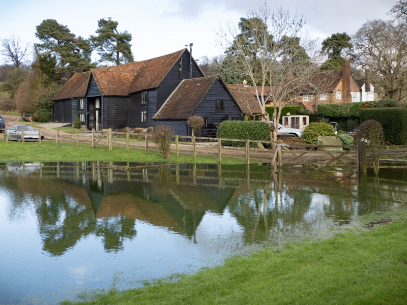
1. SWING GATE LANE
(South Side)
839
Farm Buildings at
SP 90 NE Bottom Farm
3/240
II CV
2.
Farm buildings, N range now in domestic use. C16 barn in W range incorporating an
older N bay, C18 traphouse with loft at S end and 2-bay C19 open shed at N end. C19
elevated granary at E end of N range which has C17/C18 parts linked and adapted to
domestic use in 1980s. Timber frames on brick sills, dark weatherboarded with
steep old red tile roofs. A picturesque L-shaped group of farm buildings to W of
house. The 4-bay barn faces W with a gabled projecting porch in the 2nd bay from S
and a large winnowing door opposite on E and rear outshuts and stables under
catslide roofs. Jowled posts with mid-height rails in-line and unjowled wallposts
at mid-bay. Heavy straight braces to tie beams and to wallplates. 2 purlins to
each slope of clasped purlin roof, the upper clasped by a collar and the lower by
quadrant-curved inclined queen-posts. Older N bay had a single-purlin with wind
braces but was altered to 2 butt-purlins. Straight wind braces to lower purlins.
Squint-butted scarf joint in wall plate. Old elm boards on rear of barn survive
protected by outshuts. Square single-storey C19 granary raised high on 2 parallel
brick walls has a pyramidial roof, small window in middle of each side and door
central at E reached by ladder. Interior has a central N-S tie-beam with inclined
queen-posts to purlin roof with angle rafters bearing on ties across the corners
with pegged tenons. Long diagonal braces in walls.
Listing NGR: SP9998806089
External links are from the relevant listing authority and, where applicable, Wikidata. Wikidata IDs may be related buildings as well as this specific building. If you want to add or update a link, you will need to do so by editing the Wikidata entry.


Other nearby listed buildings