Approximate Location Map
Large Map »
Latitude: 51.5721 / 51°34'19"N
Longitude: -0.1497 / 0°8'58"W
OS Eastings: 528326
OS Northings: 187536
OS Grid: TQ283875
Mapcode National: GBR DT.NXR
Mapcode Global: VHGQL.CR66
Plus Code: 9C3XHVC2+R4
Entry Name: Gas Lamp
Listing Date: 17 October 1995
Grade: II
Source: Historic England
Source ID: 1249712
English Heritage Legacy ID: 431918
ID on this website: 101249712
Location: Parliament Hill, Haringey, London, N6
County: London
District: Haringey
Electoral Ward/Division: Highgate
Parish: Non Civil Parish
Built-Up Area: Haringey
Traditional County: Middlesex
Lieutenancy Area (Ceremonial County): Greater London
Church of England Parish: St Michael Highgate
Church of England Diocese: London
Tagged with: Gas streetlight
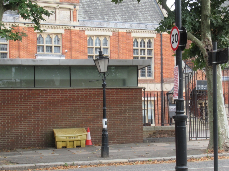
TQ 2887 NORTH ROAD
800-/40/10038 Gas lamp
II
Gas lamp. Late C19. Cast Iron. Chamfered base in Gothic design. Small Corinthian capital at the
top supports the mantle apparatus and four-sided glass lantern. Listed as a complete example of a
Victorian gas lamp and a rare survival.
Listing NGR: TQ2832887542
External links are from the relevant listing authority and, where applicable, Wikidata. Wikidata IDs may be related buildings as well as this specific building. If you want to add or update a link, you will need to do so by editing the Wikidata entry.


Other nearby listed buildings
