Approximate Location Map
Large Map »
Latitude: 51.2267 / 51°13'36"N
Longitude: 0.5108 / 0°30'38"E
OS Eastings: 575410
OS Northings: 150501
OS Grid: TQ754505
Mapcode National: GBR PRS.3XN
Mapcode Global: VHJML.SFWF
Plus Code: 9F326GG6+M8
Entry Name: Hill Place
Listing Date: 23 May 1967
Grade: II
Source: Historic England
Source ID: 1250299
English Heritage Legacy ID: 432595
ID on this website: 101250299
Location: Maidstone, Kent, ME17
County: Kent
District: Maidstone
Civil Parish: Linton
Traditional County: Kent
Lieutenancy Area (Ceremonial County): Kent
Church of England Parish: Linton St Nicholas
Church of England Diocese: Rochester
Tagged with: Building
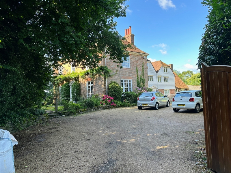
LINTON HILL
TQ 75 SE LINTON
(West Side)
3/153 Hill Place
23.5.67
GV II
Farmhouse. Mid C17 with later C18 front range. Front range red and grey
brick in English bond, formerly painted. Rear range timber framed:
left (south) side red and grey brick in English bond to ground floor,
first floor rendered. Plain tile roof. L-plan C17 range; longest
elevation facing south, shorter wing facing east. Later addition
infilling re-entrant angle to north. Later C18 block added towards road
to east end. Front (east) elevation: 2 storeys on galleted stone plinth.
Plat band. Modillioned wood eaves cornice. Hipped roof, hips returning.
2 rear stacks, and ridge stack to C17 range. Regular 3-window front of
two 16-pane sashes and central 12-pane sash, in open boxes, with splayed
rubbed brick voussoirs. Central half-glazed door in panelled recess;
semi-circular fanlight with radiating glazing bars. Architrave of plain
pilasters, with modillioned frieze, rosette paterae and broken-based
triangular pediment. North elevation: adjacent gable ends of C17 range
and later infilling both brick on ground floor, weatherboarded above.
2 storeys and garret with half-hipped roofs to north. 2-light leaded
garret casement to C17 range. Panelled door to ground floor below, with
shouldered architrave and moulded and dentilled triangular pediment.
Interior: exposed framing. Late C18 staircase.
Listing NGR: TQ7541850498
External links are from the relevant listing authority and, where applicable, Wikidata. Wikidata IDs may be related buildings as well as this specific building. If you want to add or update a link, you will need to do so by editing the Wikidata entry.


Other nearby listed buildings
