Approximate Location Map
Large Map »
Latitude: 50.95 / 50°56'59"N
Longitude: 0.7314 / 0°43'53"E
OS Eastings: 591956
OS Northings: 120280
OS Grid: TQ919202
Mapcode National: GBR QXP.CQX
Mapcode Global: FRA D6FL.LSD
Plus Code: 9F22WPXJ+XH
Entry Name: Hartshorn House the Link
Listing Date: 12 October 1951
Last Amended: 8 August 1968
Grade: II*
Source: Historic England
Source ID: 1251959
English Heritage Legacy ID: 434850
ID on this website: 101251959
Location: Rye, Rother, East Sussex, TN31
County: East Sussex
District: Rother
Civil Parish: Rye
Built-Up Area: Rye
Traditional County: Sussex
Lieutenancy Area (Ceremonial County): East Sussex
Church of England Parish: Rye
Church of England Diocese: Chichester
Tagged with: Architectural structure
1.
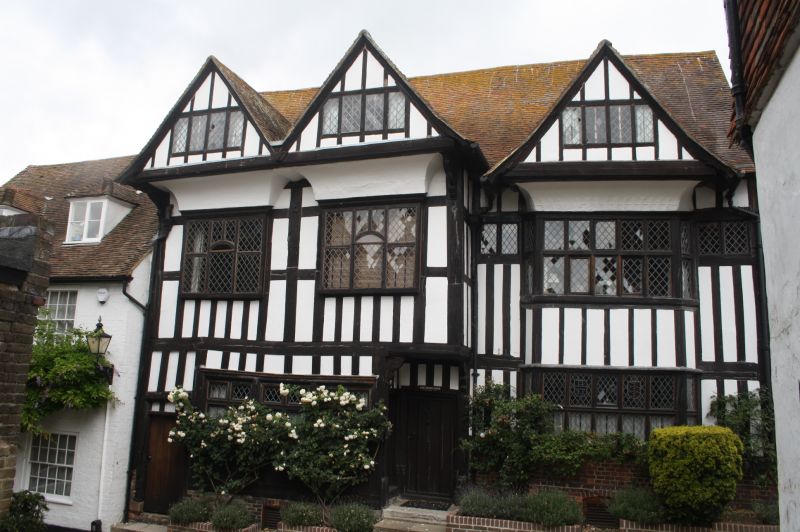
1578 MERMAID STREET
(North Side)
TQ 9120 1/122 12.10.51 No 31 (Hartshorn House).
8.8.68. The Link.
II" (NO 31) GV
II
2.
This was built as a private house and the name dates only from the Napoleonic
wars, when the house was used as a hospital. The front portion is a C15
timber-framed house of which many of the timbers have been renewed. The
1st floor overhangs on brackets shaped like a double volute. 3 gables
added in the C16 (one dated 1576) carried on curved coving and brackets.
Tiled roof. Modern easement windows. At the west end of the house is
a passageway through the house on the ground floor with a wrought iron
gate. The VCH says that there is a C16 wing behind and that the house
has a stone vaulted cellar, Tudor fireplaces and C18 panelling. To the
east is an C18 house which has been rebuilt in modern times and is now
used as the service wing of the Old Hospital. This has 2 storeys and 3
windows. Red brick and grey headers. Wooden cornice and tiled roof, all
renewed. 6-panel moulded door. There is another mediaeval cellar beneath
this house.
All the listed buildings in Mermaid Street form a group.
Listing NGR: TQ9195620280
External links are from the relevant listing authority and, where applicable, Wikidata. Wikidata IDs may be related buildings as well as this specific building. If you want to add or update a link, you will need to do so by editing the Wikidata entry.


Other nearby listed buildings
