Approximate Location Map
Large Map »
Latitude: 50.9499 / 50°56'59"N
Longitude: -2.7157 / 2°42'56"W
OS Eastings: 349822
OS Northings: 116966
OS Grid: ST498169
Mapcode National: GBR MK.NHSJ
Mapcode Global: FRA 566L.MTJ
Plus Code: 9C2VW7XM+XP
Entry Name: The Chantry
Listing Date: 27 October 1987
Grade: II
Source: Historic England
Source ID: 1252008
English Heritage Legacy ID: 434927
ID on this website: 101252008
Location: Montacute, Somerset, TA15
County: Somerset
District: South Somerset
Civil Parish: Montacute
Built-Up Area: Montacute
Traditional County: Somerset
Lieutenancy Area (Ceremonial County): Somerset
Tagged with: Architectural structure
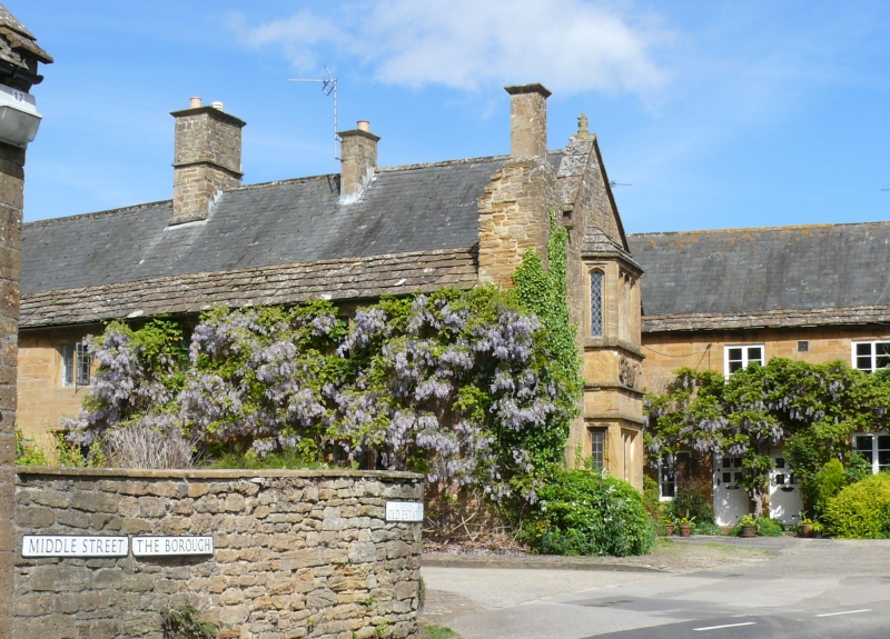
ST4916 MONTACUTE CP THE BOR0UGH (East side)
8/107 No. 2
(The Chantry)
(formerly listed as The Post
Office)
GV II
Semi-detached house. Probably C17, but incorporating C16 work. Ham stone coursed rubble with ashlar dressings; Welsh
slate roof with stone slate base courses between stepped coped gables; stone chimney stacks. Two storeys, 2 bay west
elevation. Hollow-chamfered mullioned windows in chamfered recesses, 3-light below and 2-light above, all flat-headed
lights except to upper bay 1 which has 4-centre arched lights; substantial chimney stick to south-west corner. South
gable has a 2-storey angled bay window of 1+3+1 hollow-chamfer mullioned lights in chamfered recesses, the lower with
flat heads and the upper 4-centre arched with incised spandrils under stepped hipped stone roof; there are 2 string
moulds over the lower window, and then a carved panel for full width of bay featuring 2 figures carrying a shield
bearing the letters R.S (for the last prior of Montacute 1532-39) and sways: to right a triangular-arched doorway
without label, plain boarded door. Sundry extensions to east. Interior not seen. (VCR Vol III,1974).
Listing NGR: ST4982216966
External links are from the relevant listing authority and, where applicable, Wikidata. Wikidata IDs may be related buildings as well as this specific building. If you want to add or update a link, you will need to do so by editing the Wikidata entry.


Other nearby listed buildings
