Latitude: 53.4086 / 53°24'31"N
Longitude: -2.9821 / 2°58'55"W
OS Eastings: 334809
OS Northings: 390651
OS Grid: SJ348906
Mapcode National: GBR 74N.X2
Mapcode Global: WH877.5L67
Plus Code: 9C5VC259+F5
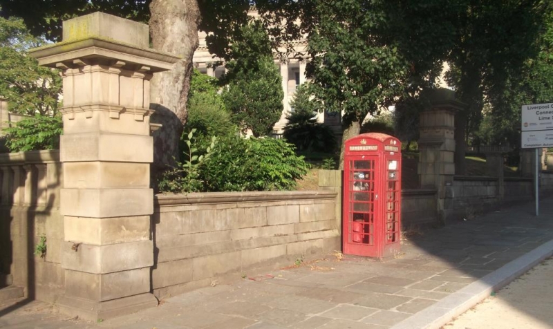
Entry Name: K6 Telephone Kiosk
Listing Date: 19 May 1989
Grade: II
Source: Historic England
Source ID: 1252897
English Heritage Legacy ID: 436008
ID on this website: 101252897
Location: Liverpool, Merseyside, L1
County: Liverpool
Electoral Ward/Division: Central
Parish: Non Civil Parish
Built-Up Area: Liverpool
Traditional County: Lancashire
Lieutenancy Area (Ceremonial County): Merseyside
Church of England Parish: Liverpool Our Lady and St Nicholas
Church of England Diocese: Liverpool
Tagged with: K6 telephone box
SJ 3490 NE ST JOHNS LANE (L1)
49/1500A K6 Telephone Kiosk
GV II
Telephone kiosk, Type K6. Designed 1935 by Sir Giles Gilbert Scott. Made by various
contractors. Cast Iron. Square kiosk with domed roof. Unperforated crowns to top
panels and margin glazing to windows and door.
Listing NGR: SJ3480990651
External links are from the relevant listing authority and, where applicable, Wikidata. Wikidata IDs may be related buildings as well as this specific building. If you want to add or update a link, you will need to do so by editing the Wikidata entry.


Other nearby listed buildings