Approximate Location Map
Large Map »
Latitude: 53.4169 / 53°25'0"N
Longitude: -2.7679 / 2°46'4"W
OS Eastings: 349056
OS Northings: 391398
OS Grid: SJ490913
Mapcode National: GBR 9X3X.JV
Mapcode Global: WH87B.GC5W
Plus Code: 9C5VC68J+QR
Entry Name: Skew Bridge
Listing Date: 28 May 1958
Grade: II
Source: Historic England
Source ID: 1253244
English Heritage Legacy ID: 436402
ID on this website: 101253244
Location: Rainhill, St. Helens, Merseyside, L35
County: St. Helens
Civil Parish: Rainhill
Built-Up Area: Prescot
Traditional County: Lancashire
Lieutenancy Area (Ceremonial County): Merseyside
Church of England Parish: Rainhill St Ann
Church of England Diocese: Liverpool
Tagged with: Bridge
1.
2487 RAINHILL RAINHILL
Warrington Road
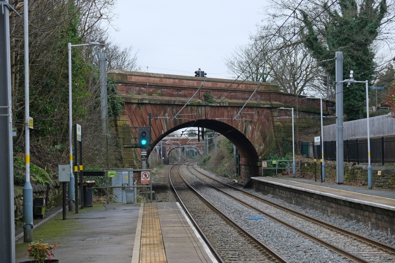
Skew Bridge
SJ 49 SE 7/42 28.5.58.
II
2.
1829, built to carry Liverpool-Warrington road over Liverpool-Manchester
railway. Stone, single arch, inscribed George Stephenson engineer. A
good bridge (difficult to see except from railway) and one of the earliest
of the railway age. Red sandstone, but South side rebuilt with metal
parapet.
Listing NGR: SJ4905691398
External links are from the relevant listing authority and, where applicable, Wikidata. Wikidata IDs may be related buildings as well as this specific building. If you want to add or update a link, you will need to do so by editing the Wikidata entry.


Other nearby listed buildings
