Latitude: 52.6955 / 52°41'43"N
Longitude: -2.7822 / 2°46'55"W
OS Eastings: 347234
OS Northings: 311160
OS Grid: SJ472111
Mapcode National: GBR BH.37Q8
Mapcode Global: WH8BT.7HDW
Plus Code: 9C4VM6W9+64
Entry Name: Conduit Head
Listing Date: 30 May 1969
Last Amended: 17 November 1995
Grade: II
Source: Historic England
Source ID: 1254701
English Heritage Legacy ID: 457785
ID on this website: 101254701
Location: Radbrook, Shropshire, SY3
County: Shropshire
Civil Parish: Shrewsbury
Built-Up Area: Shrewsbury
Traditional County: Shropshire
Lieutenancy Area (Ceremonial County): Shropshire
Church of England Parish: Meole Brace Holy Trinity
Church of England Diocese: Lichfield
Tagged with: Architectural structure
SJ41 SE
653-1/4/767
30/05/69
SHREWSBURY
NOBOLD LANE, Radbrook
(East side)
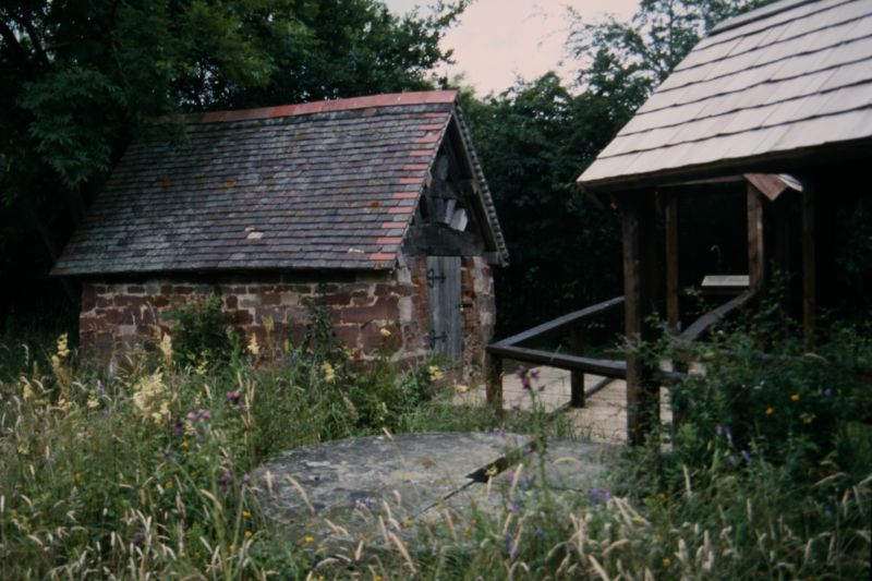
Conduit head
(Formerly Listed as:
The Broad Well Conduit House)
II
Conduit head. Original structure late C16 with later
alterations. Roughly coursed and squared red sandstone with
timber-framed trusses in each gable and plain tiled roof.
Small gabled structure comprising a single chamber accessed by
small inserted doorway in gable, with brick lined water tank
inside. Gables have cambered trusses with bracing and collar,
and are slatted.
HISTORICAL NOTE: the conduit head was a collecting tank
associated with 9 wells in the vicinity, and provided a source
of water for the town of Shrewsbury from 1556, the present
building probably completed by 1578. Water was piped from this
site, known as Broadwell, to several points within the town.
The system was established under licence to the Corporation,
and was acquired by the Corporation in 1878. It remained in
use until 1947. Some of the urban conduit heads associated
with this system still survive (Betton Street, Porthill Road,
St Michael's Street, Sundorne Road, Town Walls (qv)).
Listing NGR: SJ4723411160
External links are from the relevant listing authority and, where applicable, Wikidata. Wikidata IDs may be related buildings as well as this specific building. If you want to add or update a link, you will need to do so by editing the Wikidata entry.


Other nearby listed buildings