Approximate Location Map
Large Map »
Latitude: 52.7084 / 52°42'30"N
Longitude: -2.7543 / 2°45'15"W
OS Eastings: 349133
OS Northings: 312572
OS Grid: SJ491125
Mapcode National: GBR BJ.2GLY
Mapcode Global: WH8BT.N6M0
Plus Code: 9C4VP65W+97
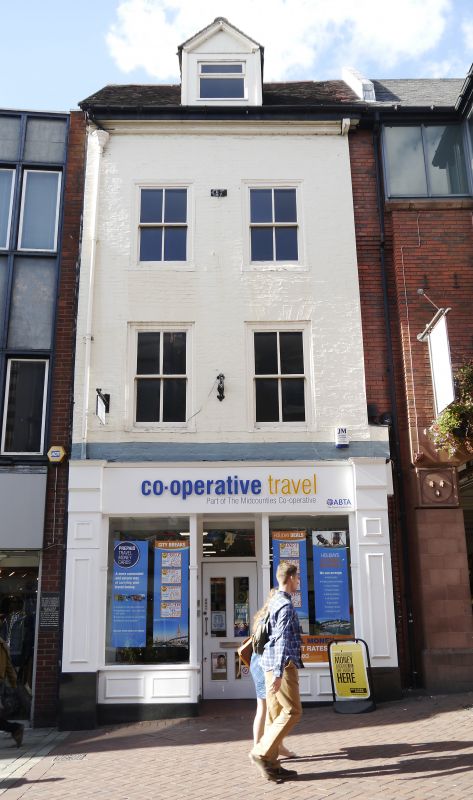
Entry Name: 4, Pride Hill
Listing Date: 19 September 1972
Grade: II
Source: Historic England
Source ID: 1254718
English Heritage Legacy ID: 457797
ID on this website: 101254718
Location: Shrewsbury, Shropshire, SY1
County: Shropshire
Civil Parish: Shrewsbury
Built-Up Area: Shrewsbury
Traditional County: Shropshire
Lieutenancy Area (Ceremonial County): Shropshire
Church of England Parish: Shrewsbury St Alkmund
Church of England Diocese: Lichfield
Tagged with: Building
SHREWSBURY
SJ4912NW PRIDE HILL
653-1/11/481 (North West side)
19/09/72 No.4
GV II
Shop, possibly originally dwelling. Late C18. Painted brick
with plain tiled roof. 3 storeys, 2-window range, with
inserted late C20 shop front and 4-pane sashes with
flat-arched gauged brick heads. Plain wood eaves cornice,
single dormer in roof.
Listing NGR: SJ4913312572
External links are from the relevant listing authority and, where applicable, Wikidata. Wikidata IDs may be related buildings as well as this specific building. If you want to add or update a link, you will need to do so by editing the Wikidata entry.


Other nearby listed buildings
