Approximate Location Map
Large Map »
Latitude: 52.9516 / 52°57'5"N
Longitude: -1.1548 / 1°9'17"W
OS Eastings: 456885
OS Northings: 339690
OS Grid: SK568396
Mapcode National: GBR LNQ.32
Mapcode Global: WHDGZ.72CK
Plus Code: 9C4WXR2W+J3
Entry Name: Pair of Boundary Marks Opposite Number 5
Listing Date: 30 November 1995
Grade: II
Source: Historic England
Source ID: 1255109
English Heritage Legacy ID: 458566
ID on this website: 101255109
Location: Standard Hill, Nottingham, Nottinghamshire, NG1
County: City of Nottingham
Electoral Ward/Division: Radford and Park
Parish: Non Civil Parish
Built-Up Area: Nottingham
Traditional County: Nottinghamshire
Lieutenancy Area (Ceremonial County): Nottinghamshire
Church of England Parish: Nottingham St Nicholas
Church of England Diocese: Southwell and Nottingham
Tagged with: Boundary marker
This List entry was subject to a Minor Amendment on 22/02/2018
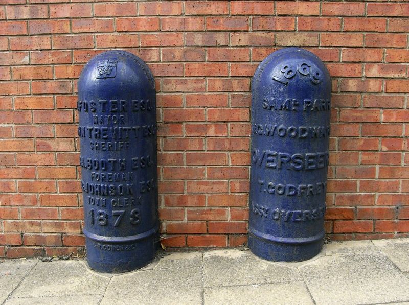
SK 5639 NE; 646-1/19/592
NOTTINGHAM,
ST JAMES' TERRACE (south-west side),
Pair of boundary marks opposite No. 5 (not included)
GV
II
Two boundary marks. Dated 1869 and 1878. Cast-iron. Semicircular
section with rounded tops and raised lettering. Mark to right,
1869, has names of Overseers of the Poor. That to left, 1878,
has the names of the Mayor, Sheriff, and other City officials.
These marks reflect attempts by the City to establish its
jurisdiction in the Standard Hill area, and collect poor rates
there.
(Get to know Nottingham: Brand K: The Park estate, Nottingham:
Nottingham: 1984-: 9).
Listing NGR: SK5688539689
External links are from the relevant listing authority and, where applicable, Wikidata. Wikidata IDs may be related buildings as well as this specific building. If you want to add or update a link, you will need to do so by editing the Wikidata entry.


Other nearby listed buildings
