Latitude: 53.8092 / 53°48'33"N
Longitude: -1.5806 / 1°34'50"W
OS Eastings: 427713
OS Northings: 434852
OS Grid: SE277348
Mapcode National: GBR B9G.38
Mapcode Global: WHC9C.PJJ4
Plus Code: 9C5WRC59+MQ
Entry Name: Burley Methodist Church Hall
Listing Date: 11 September 1996
Grade: II
Source: Historic England
Source ID: 1255671
English Heritage Legacy ID: 465753
ID on this website: 101255671
Location: Burley, Leeds, West Yorkshire, LS4
County: Leeds
Electoral Ward/Division: Kirkstall
Parish: Non Civil Parish
Built-Up Area: Leeds
Traditional County: Yorkshire
Lieutenancy Area (Ceremonial County): West Yorkshire
Church of England Parish: Burley St Matthias
Church of England Diocese: Leeds
Tagged with: Building
LEEDS
SE2734 CARDIGAN LANE, Burley 714-1/28/564 (West side) Burley Methodist Church Hall
GV II
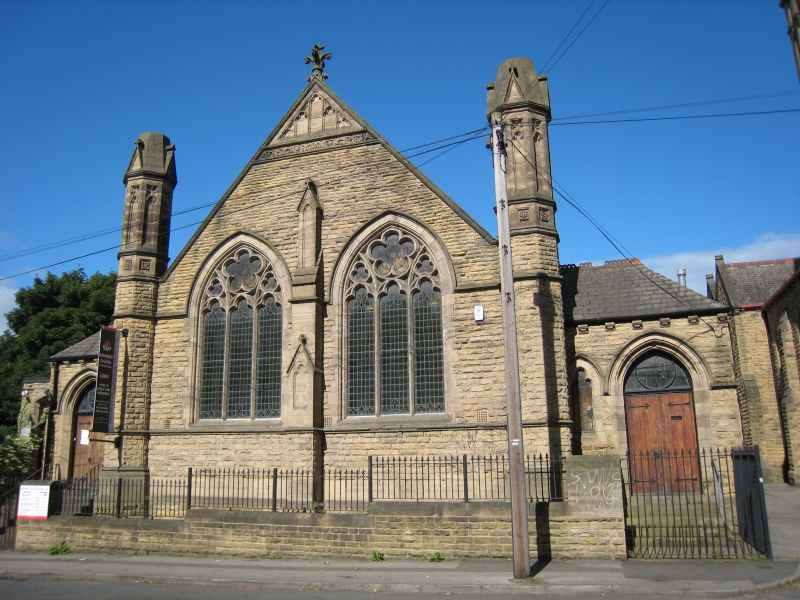
Sunday school, now church hall. 1904. Coursed squared rock-faced gritstone, ashlar details. Single storey, 3 bays, gable to road. Gothic Revival style. Road facade: paired 3-light windows with decorated tracery, gabled buttress between, carved band and traceried panel at apex, crocketed pinnacle; octagonal corner turrets with traceried panels and truncated gabled spirelets. Entrance bay with hipped roof right: wide doorway in moulded arch with traceried overlight, cusped window left and on right return. Right return: low lean-to with mullioned windows, gabled clerestory windows with trefoil tracery. INTERIOR: not inspected.
Listing NGR: SE2771334852
External links are from the relevant listing authority and, where applicable, Wikidata. Wikidata IDs may be related buildings as well as this specific building. If you want to add or update a link, you will need to do so by editing the Wikidata entry.


Other nearby listed buildings