Approximate Location Map
Large Map »
Latitude: 53.7917 / 53°47'30"N
Longitude: -1.554 / 1°33'14"W
OS Eastings: 429475
OS Northings: 432916
OS Grid: SE294329
Mapcode National: GBR BGN.RK
Mapcode Global: WHC9D.3Y7K
Plus Code: 9C5WQCRW+M9
Entry Name: Bridge over Hol Beck
Listing Date: 11 September 1996
Grade: II
Source: Historic England
Source ID: 1255738
English Heritage Legacy ID: 465681
ID on this website: 101255738
Location: Camp Field, Leeds, West Yorkshire, LS11
County: Leeds
Electoral Ward/Division: City and Hunslet
Parish: Non Civil Parish
Built-Up Area: Leeds
Traditional County: Yorkshire
Lieutenancy Area (Ceremonial County): West Yorkshire
Church of England Parish: Hunslet St Mary the Virgin
Church of England Diocese: Leeds
Tagged with: Bridge
LEEDS
SE2932 WATER LANE, Holbeck
714-1/42/860 (North side)
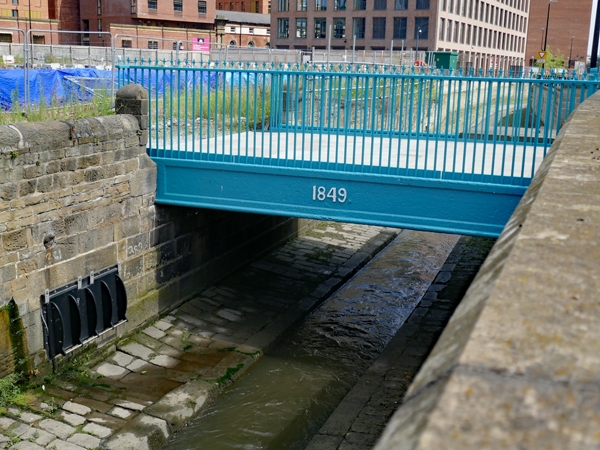
Bridge over Hol Beck
GV II
Bridge, flanking railings, and south piers. Dated 1849. For
Marshall's Flax Mill. Cast-iron. Bridge of single flat span,
approx 4m wide, the exposed faces having a roll moulding and
recessed panel with the date in relief. Railing: spearhead
finials above moulded rail, column-style standard at north
ends, finials missing. Piers: square section, approx 1.75m
tall; plinth, recessed panel, moulded cornice survives to
left.
This structure replaced a wooden bridge probably of c1808
which linked the flax spinning mill built by John Marshall on
the north side of Hol Beck with his new warehouse on the south
side, now on the corner of Marshall Street (qv).
HISTORICAL NOTE: Marshall's mill properties were developed
southwards, away from the original mill, as far as the Temple
Mill, completed in 1843 (qv). The old mill continued in use
and is shown in detail on the 1847 Ordnance Survey map, the
wooden bridge carrying all the traffic between the two parts
of the works.
The construction of the new bridge coincides with the
establishment of the line of Globe Road by 1850, but at that
date Marshall's property was the only complex between the Hol
Beck and the canal. By 1866 Marshall's had ceased to use the
buildings north of the bridge and the site was almost clear;
the Globe Foundry had been built and was beginning to expand
on the north side of Globe Road (qv). The bridge therefore
dates from the final use of the north side of Hol Beck by
Marshall's Flax Mill; the firm closed in 1886.
(Captain Tucker, surveyor: Ordnance Survey Map scale 5 feet: 1
mile: 1847-1850; Rapkin J: A map of Leeds: 1850-; Brierley W:
Map of the Town of Leeds and its Vicinity: 1866-).
Listing NGR: SE2947532916
External links are from the relevant listing authority and, where applicable, Wikidata. Wikidata IDs may be related buildings as well as this specific building. If you want to add or update a link, you will need to do so by editing the Wikidata entry.


Other nearby listed buildings
