Latitude: 53.7917 / 53°47'30"N
Longitude: -1.5513 / 1°33'4"W
OS Eastings: 429658
OS Northings: 432910
OS Grid: SE296329
Mapcode National: GBR BHN.CL
Mapcode Global: WHC9D.4YKM
Plus Code: 9C5WQCRX+MF
Entry Name: 97, Water Lane
Listing Date: 25 August 1987
Last Amended: 11 September 1996
Grade: II
Source: Historic England
Source ID: 1255778
English Heritage Legacy ID: 465675
ID on this website: 101255778
Location: Camp Field, Leeds, West Yorkshire, LS11
County: Leeds
Electoral Ward/Division: City and Hunslet
Parish: Non Civil Parish
Built-Up Area: Leeds
Traditional County: Yorkshire
Lieutenancy Area (Ceremonial County): West Yorkshire
Church of England Parish: Hunslet St Mary the Virgin
Church of England Diocese: Leeds
Tagged with: Building
LEEDS
SE2932NE WATER LANE, Holbeck 714-1/80/856 (South side) 25/08/87 No.97 (Formerly Listed as: WATER LANE (South side) No.97 Former foundry workshop at junction with David Street)
GV II
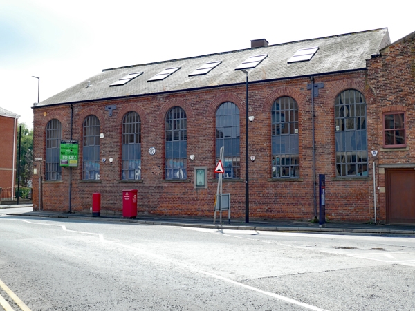
Foundry workshop, now offices. c1857-77. Restored and converted 1989. Red/brown brick in English 5:1 bond, Welsh slate roof. One tall storey, 7 bays. Street frontage of multi-pane round-arched windows with curved-edged brick surrounds and stone sills. At eaves, nail-head and chamfered brick decorative bands. Roof lights. Left return: ends of regularly-set tie bar plates on 5 levels, inserted round-arched entrance. Rear rebuilt C20. An iron plaque in polished stone surround between bays 4 and 5 was erected in 1929 and records the achievements of Matthew Murray at the Round Foundry, Foundry Street (qv). INTERIOR: not inspected. When Murray's business closed in 1843 the works were taken over and expanded by Smith, Beacock and Tannett, Machine Tool Manufacturers, and renamed the Victoria Foundry. This building is similar in character to the earlier Murray foundry at No.103 Water Lane, (qv) and was built on the site of the entrance gate on Camp Fields; it was originally entered from the greensand foundry, No.99 Water Lane (qv). The building continued in use as a foundry until 1895. (Redman RN: The Railway Foundry, Leeds, 1839-1969: Norwich: 1972-; Brierley, W: Map of the Town of Leeds and its Vicinity: 1866-).
Listing NGR: SE2965832910
External links are from the relevant listing authority and, where applicable, Wikidata. Wikidata IDs may be related buildings as well as this specific building. If you want to add or update a link, you will need to do so by editing the Wikidata entry.


Other nearby listed buildings