Approximate Location Map
Large Map »
Latitude: 53.8078 / 53°48'28"N
Longitude: -1.5575 / 1°33'26"W
OS Eastings: 429237
OS Northings: 434706
OS Grid: SE292347
Mapcode National: GBR BGG.0S
Mapcode Global: WHC9D.1KM6
Plus Code: 9C5WRC5V+42
Entry Name: Agricultural Sciences Building, University of Leeds, and Attached Railings
Listing Date: 11 September 1996
Grade: II
Source: Historic England
Source ID: 1255827
English Heritage Legacy ID: 465632
Also known as: School of Geography, University of Leeds
Geography Building, University of Leeds
Geography Building
ID on this website: 101255827
Location: Woodhouse, Leeds, West Yorkshire, LS2
County: Leeds
Electoral Ward/Division: Hyde Park and Woodhouse
Parish: Non Civil Parish
Built-Up Area: Leeds
Traditional County: Yorkshire
Lieutenancy Area (Ceremonial County): West Yorkshire
Church of England Parish: Leeds St George
Church of England Diocese: Leeds
Tagged with: Academic department University building Geography department
LEEDS
SE2934NW UNIVERSITY ROAD, University Campus
714-1/71/1174 (North side)
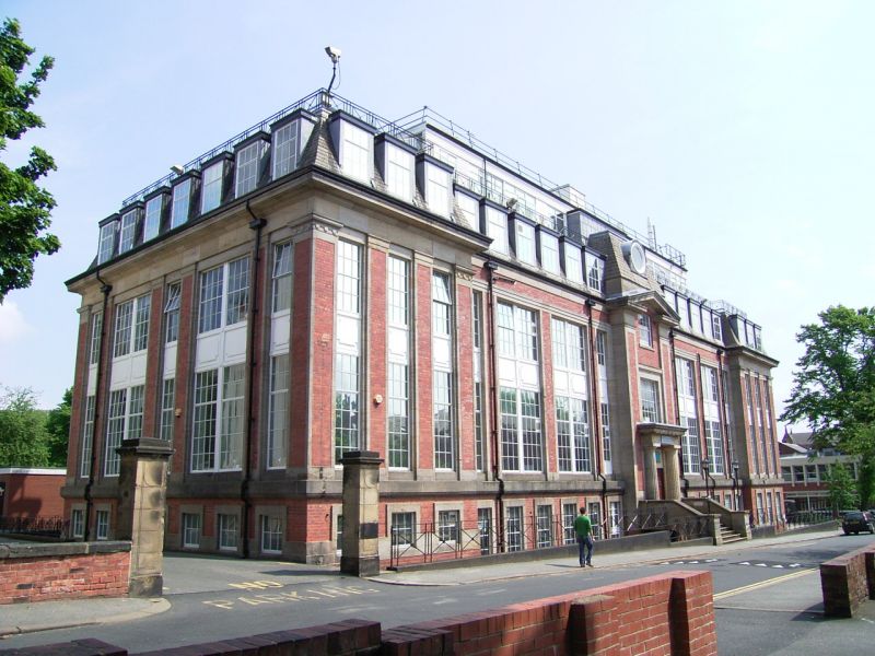
Agricultural Sciences building,
University of Leeds, and attached
railings
II
University agricultural sciences building with walling, gate
piers and railings to front. 1923. By Paul Waterhouse. Steel
frame, red brick, stone details, slate roof, cast-iron
railings, ashlar gate piers.
2 storeys with basement and attic storeys, 5 bays, the outer
bays break forward slightly; 3:4:1:4:3 windows. Centre bay:
steps with low flanking walls to double board door in Tuscan
surround with entablature and cornice, corner pilasters rise
to a broken pediment at eaves level; pavilion roof with
circular dormer above. Pilasters and pavilion roofs to outer
bays, cornice overall and flat roofed dormers to attic storey;
added glazed range above. Fenestration: full, height
small-paned windows with pivoted opening lights throughout,
raised panels between ground and 1st floors.
INTERIOR: the entrance lobby and stair hall are lined out with
bright green tiles; staircase with geometric balustrade and
ramped wooden handrail.
SUBSIDIARY FEATURES: railings: X-motif to rails on the ridge
cresting and front wall which is approx 50m long. Pair of gate
piers to left: square section, approx 2.5m tall, cornice and
shallow pyramid caps.
HISTORICAL NOTE: in 1913 the Board of Agriculture agreed to
match a donation of »10,000 from Walter Morrison for a new
Agriculture building; In 1915 a moratorium was placed on the
Ministry expenditure and after WWI the cost had almost
doubled. By 1922 plans were agreed for this building and the
site moved from Woodhouse Lane to University Road. (MW
Beresford, in Gosden and Taylor 1975, p.157)
(Studies in the History of a University: 1975-: 157).
Listing NGR: SE2923734706
External links are from the relevant listing authority and, where applicable, Wikidata. Wikidata IDs may be related buildings as well as this specific building. If you want to add or update a link, you will need to do so by editing the Wikidata entry.


Other nearby listed buildings
