Approximate Location Map
Large Map »
Latitude: 53.8192 / 53°49'9"N
Longitude: -1.6047 / 1°36'16"W
OS Eastings: 426123
OS Northings: 435956
OS Grid: SE261359
Mapcode National: GBR B3B.YP
Mapcode Global: WHC9C.B83F
Plus Code: 9C5WR99W+M4
Entry Name: Kirkabbey Kennels, Sluice Gates, Cottage and Weir on River Aire
Listing Date: 11 September 1996
Grade: II
Source: Historic England
Source ID: 1255851
English Heritage Legacy ID: 465567
ID on this website: 101255851
Location: Kirkstall, Leeds, West Yorkshire, LS5
County: Leeds
Electoral Ward/Division: Kirkstall
Parish: Non Civil Parish
Built-Up Area: Leeds
Traditional County: Yorkshire
Lieutenancy Area (Ceremonial County): West Yorkshire
Church of England Parish: Kirkstall St Stephen
Church of England Diocese: Leeds
Tagged with: Cottage
LEEDS
SE2635 BRIDGE ROAD, Kirkstall
714-1/22/894 (North side (off))
Kirkabbey Kennels, sluice gates,
cottage and weir on River Aire
GV II
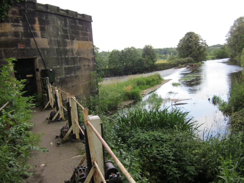
Weir on River Aire, sluice gates for Abbey Mills goit
headrace, and keeper's cottage with retaining walls. Medieval
weir site, sluice gates and cottage early C19 rebuilds, with
C20 alterations.
Weir approx 80m wide, of huge gritstone blocks, revetment wall
on W side of river similar. Cottage in Gothic Revival style at
E end of the weir: single storey, ashlar, roof hidden by
crenellated parapet; N side (upstream) has 6-panel door and
lancet window towards sluice gates, and a rebuilt 3-light
oriel window facing the river; C20 additions on S side. The
sluice gates: 8 vertical paddles, walkway over, between
cottage entrance and screen wall which is crenellated,
pilasters.
A very important point of control for the water power from
Abbey to Burley Mills, Kirkstall Road (qv); the weir is
thought to have been first built to create a depth of water at
Kirkstall Abbey, Abbey Road (qv) when building stone was being
floated down the Aire.
Listing NGR: SE2612335956
External links are from the relevant listing authority and, where applicable, Wikidata. Wikidata IDs may be related buildings as well as this specific building. If you want to add or update a link, you will need to do so by editing the Wikidata entry.


Other nearby listed buildings
