Latitude: 53.9525 / 53°57'9"N
Longitude: -1.0757 / 1°4'32"W
OS Eastings: 460751
OS Northings: 451111
OS Grid: SE607511
Mapcode National: GBR NQXQ.XW
Mapcode Global: WHFC3.FXZ9
Plus Code: 9C5WXW3F+2P
Entry Name: Ivy Cottage
Listing Date: 24 June 1983
Grade: II
Source: Historic England
Source ID: 1257842
English Heritage Legacy ID: 463391
ID on this website: 101257842
Location: Clementhorpe, York, North Yorkshire, YO10
County: York
Electoral Ward/Division: Fishergate
Parish: Non Civil Parish
Built-Up Area: York
Traditional County: Yorkshire
Lieutenancy Area (Ceremonial County): North Yorkshire
Church of England Parish: York St Lawrence with St Nicholas
Church of England Diocese: York
Tagged with: Cottage
YORK
SE6051SE FISHERGATE 1112-1/22/327 (East side) 24/06/83 No.33 Ivy Cottage
II
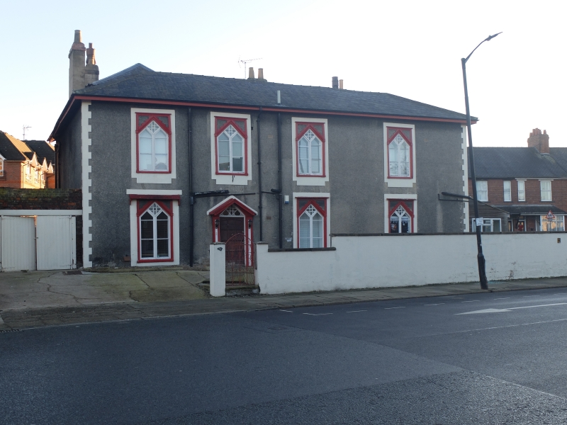
House, now hotel. Early C19 with C20 alterations. Pebbledash with painted rendered dressings. Hipped slate roof. EXTERIOR: 2 storeys. West facade 4 bays with quoins of painted render. The windows are rectangular and have timber architraves within surrounds of painted render. Within the architrave each has a moulded triangular head above 2 casement lights, which also have triangular heads. The lozenge shape formed above the heads of the casements is glazed in a 4-leafed petal pattern. The casements have plain rectangular lights replacing geometrical glazing illustrated by RCHM. The doorway is in the 2nd bay and has pilasters with sunken panels and a pedimental hood. The glazing of the triangular overlight includes the petal pattern used in the windows. The door is C20. Chimneys to left and right towards rear. The south wall is of one bay. On the 1st floor it has a window which is similar to those of the main facade. Below, it is covered by a single-storey lean-to addition. INTERIOR: not inspected. (An Inventory of the Historical Monuments of the City of York: RCHME: Outside the City Walls East of the Ouse: HMSO: 1972-: 69).
Listing NGR: SE6075151111
External links are from the relevant listing authority and, where applicable, Wikidata. Wikidata IDs may be related buildings as well as this specific building. If you want to add or update a link, you will need to do so by editing the Wikidata entry.


Other nearby listed buildings