Approximate Location Map
Large Map »
Latitude: 51.44 / 51°26'24"N
Longitude: 0.7637 / 0°45'49"E
OS Eastings: 592170
OS Northings: 174848
OS Grid: TQ921748
Mapcode National: GBR RS2.MWW
Mapcode Global: VHKJ7.622D
Plus Code: 9F32CQR7+2F
Entry Name: Memorial to Thomas Stuteley in Holy Trinity Churchyard
Listing Date: 30 June 1978
Grade: II
Source: Historic England
Source ID: 1258056
English Heritage Legacy ID: 443877
ID on this website: 101258056
Location: Holy Trinity Church, Sheerness, Swale, Kent, ME12
County: Kent
District: Swale
Electoral Ward/Division: Sheerness
Parish: Sheerness
Built-Up Area: Sheerness
Traditional County: Kent
Lieutenancy Area (Ceremonial County): Kent
Tagged with: Memorial
THE BROADWAY
1.
5282
(South-East Side)
Mile Town, Sheerness
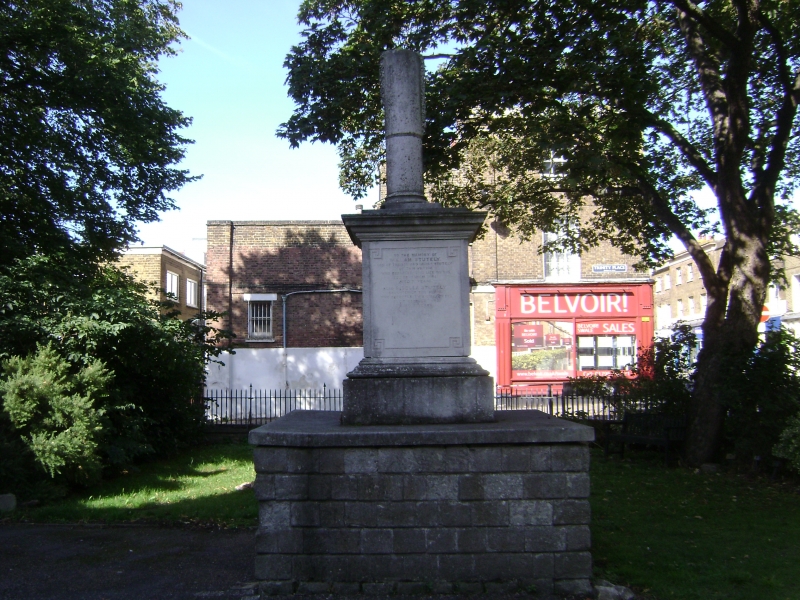
Memorial to Thomas Stuteley
in Holy Trinity Churchyard
TQ 9274 NW 9/8
II GV
2.
Dated 1879. Ashlar plinth. Stone square base with inscription and Greek key
design and broken pillar above with garland.
Listing NGR: TQ9217074848
External links are from the relevant listing authority and, where applicable, Wikidata. Wikidata IDs may be related buildings as well as this specific building. If you want to add or update a link, you will need to do so by editing the Wikidata entry.


Other nearby listed buildings
