Latitude: 51.0673 / 51°4'2"N
Longitude: -1.7972 / 1°47'50"W
OS Eastings: 414304
OS Northings: 129788
OS Grid: SU143297
Mapcode National: GBR 51F.2F8
Mapcode Global: FRA 7639.KMZ
Plus Code: 9C3W3683+W4
Entry Name: 71, New Street
Listing Date: 12 October 1972
Grade: II
Source: Historic England
Source ID: 1258406
English Heritage Legacy ID: 444926
ID on this website: 101258406
Location: Salisbury, Wiltshire, SP1
County: Wiltshire
Civil Parish: Salisbury
Built-Up Area: Salisbury
Traditional County: Wiltshire
Lieutenancy Area (Ceremonial County): Wiltshire
Church of England Parish: Salisbury St Thomas and St Edmund
Church of England Diocese: Salisbury
Tagged with: Building
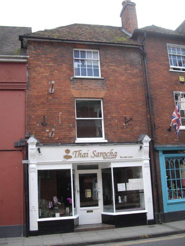
NEW STREET
1.
1594 (South Side )
No 71
SU 1429 NW 3/104
II GV
2.
Late C18. 3 storeys red brick. Half hipped old tile roof. 1 window to upper
floors, recessed sashes, no glazing bars first floor, flat arches. Late C19
shop front on ground floor, decorated pilasters, capped brackets flanking fascia.
Nos 21 to 49 (odd), the School of Arts and Crafts, Nos 61, 63 and
Nos 67 to 75 (odd) form a group.
Nos 67 to 75 (odd) also form a group with No 37 High Street.
Listing NGR: SU1430429788
External links are from the relevant listing authority and, where applicable, Wikidata. Wikidata IDs may be related buildings as well as this specific building. If you want to add or update a link, you will need to do so by editing the Wikidata entry.


Other nearby listed buildings