Approximate Location Map
Large Map »
Latitude: 50.8329 / 50°49'58"N
Longitude: -3.6675 / 3°40'2"W
OS Eastings: 282669
OS Northings: 105037
OS Grid: SS826050
Mapcode National: GBR L8.WW5K
Mapcode Global: FRA 366W.WHP
Plus Code: 9C2RR8MM+52
Entry Name: Gatehouse Approximately 30 Metres South of Dowrich House Including Rubble Walls to North East and South West
Listing Date: 26 August 1965
Grade: II
Source: Historic England
Source ID: 1258727
English Heritage Legacy ID: 445509
ID on this website: 101258727
Location: Mid Devon, EX17
County: Devon
District: Mid Devon
Civil Parish: Sandford
Traditional County: Devon
Lieutenancy Area (Ceremonial County): Devon
Church of England Parish: Sandford St Swithin
Church of England Diocese: Exeter
Tagged with: Wall
SS 80 NW SANDFORD
1/181 Gatehouse approx 30m south of
26.8.65 Dowrich House including rubble
walls to north-east and south-
west
GV II
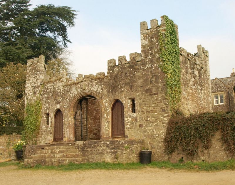
Gatehouse. Early C16, remodelled in early C19. Volcanic rubble with volcanic
ashlar dressings. Square in plan with decorative corner turrets, central
carriageway flanked by small rooms, and stone steps to raised pavement to front.
Symmetrical south-east facing 2-window front. Small flanking turrets, central
elliptical arch with moulded surround and flanking arched doorways and small outer
square-headed windows with moulded surrounds containing stancheons and saddle bars.
Embattled parapet drops down to lower level over carriageway. Raised pavement
across front and flight of volcanic ashlar semi-circular steps (some blocks with
moulded bull noses). Similar rear elevation with chamfered surrounds to
carriageway and windows. Rubble garden walls to north-east and south-west are
included for group value.
Listing NGR: SS8266905037
External links are from the relevant listing authority and, where applicable, Wikidata. Wikidata IDs may be related buildings as well as this specific building. If you want to add or update a link, you will need to do so by editing the Wikidata entry.


Other nearby listed buildings
