Approximate Location Map
Large Map »
Latitude: 53.9682 / 53°58'5"N
Longitude: -1.0941 / 1°5'38"W
OS Eastings: 459521
OS Northings: 452841
OS Grid: SE595528
Mapcode National: GBR NQSK.X7
Mapcode Global: WHFC3.5J77
Plus Code: 9C5WXW94+78
Entry Name: 68 and 70, Clifton
Listing Date: 14 March 1997
Grade: II
Source: Historic England
Source ID: 1259227
English Heritage Legacy ID: 463115
ID on this website: 101259227
Location: York, North Yorkshire, YO30
County: York
Electoral Ward/Division: Clifton
Parish: Non Civil Parish
Built-Up Area: York
Traditional County: Yorkshire
Lieutenancy Area (Ceremonial County): North Yorkshire
Church of England Parish: Clifton St Philip and St James
Church of England Diocese: York
Tagged with: Building
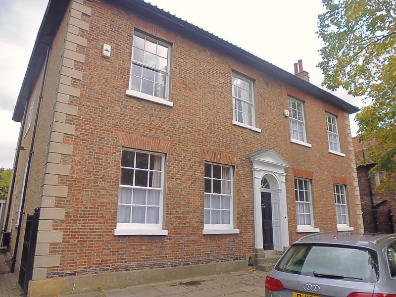
YORK
SE5952NE CLIFTON
1112-1/7/198 (North East side)
Nos.68 AND 70
GV II
House, now subdivided. c1800, extended in mid C19; reduced in
height and repaired following Second World War bomb damage.
Buff-orange brick in Flemish bond at front, rendered
elsewhere, on stone plinth; rendered quoins and timber
doorcase; rendered stacks with brick cornices to pantile roof.
EXTERIOR: 2-storey 4-window front. Central doorcase of fluted
pilasters with imposts and dentilled pediment has door of 6
raised and fielded panels and radial fanlight recessed in
panelled reveal. All windows are 12-pane sashes with slender
glazing bars, painted stone sills and flat arches of rubbed
brick, those to right of orange colour. Entrance to No.68 is a
glazed and panelled door beneath flat bracketed hood in right
return. Ground floor windows on left return are 12-pane sashes
with cambered heads: elsewhere they are C20 replacements.
INTERIOR: RCHM record that a ground floor room in No.68
contains a late C18 fire surround reset from No.56 Skeldergate
(qv).
(An Inventory of the Historical Monuments of the City of York:
RCHME: Outside the City Walls East of the Ouse: HMSO: 1975-:
94).
Listing NGR: SE5952152841
External links are from the relevant listing authority and, where applicable, Wikidata. Wikidata IDs may be related buildings as well as this specific building. If you want to add or update a link, you will need to do so by editing the Wikidata entry.


Other nearby listed buildings
