Approximate Location Map
Large Map »
Latitude: 53.9664 / 53°57'59"N
Longitude: -1.0911 / 1°5'28"W
OS Eastings: 459721
OS Northings: 452640
OS Grid: SE597526
Mapcode National: GBR NQTK.KX
Mapcode Global: WHFC3.6KNN
Plus Code: 9C5WXW85+HG
Entry Name: The White House
Listing Date: 20 August 1970
Grade: II
Source: Historic England
Source ID: 1259249
English Heritage Legacy ID: 463095
Also known as: 10 Clifton, York
ID on this website: 101259249
Location: York, North Yorkshire, YO30
County: York
Electoral Ward/Division: Clifton
Parish: Non Civil Parish
Built-Up Area: York
Traditional County: Yorkshire
Lieutenancy Area (Ceremonial County): North Yorkshire
Church of England Parish: York St Olave with St Giles
Church of England Diocese: York
Tagged with: House
YORK
SE5952NE CLIFTON
1112-1/7/183 (North East side)
20/08/70 No.10
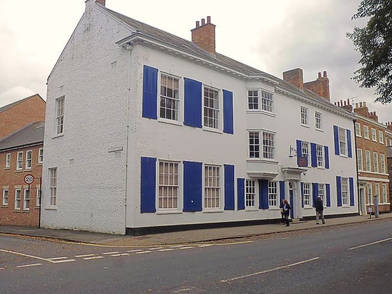
The White House
GV II
House, now offices. Early C18; heightened late C18, extended
early/mid C19 and altered later. Stucco with slate roof.
Earlier part of facade 3 storeys and 4 bays with a central
doorway.
EXTERIOR: additions to each side are of 2 storeys: of 2 bays
to the left and one to the right. The windows are glazing bar
sashes. The 1st and 2nd floor windows in the 2 bays to the
left of the door have been replaced by a C19 2-storey canted
bay window. All the windows, except those to the canted bay
and those on the 2nd floor, have external shutters. The
doorway has a fanlight and a doorcase of engaged fluted Doric
columns with a triglyph frieze and cornice. The door has 6
raised and fielded panels. Chimneys on left-hand gable, and,
in front of ridge, to each side of central 3-storey part of
building.
INTERIOR: not inspected. RCHM records late C18 curved
staircase with stone treads and plain iron balusters, and some
Adam style fireplaces.
(An Inventory of the Historical Monuments in the City of York:
RCHME: Outside the City Walls East of the Ouse: London: 1975-:
65).
Listing NGR: SE5972152640
External links are from the relevant listing authority and, where applicable, Wikidata. Wikidata IDs may be related buildings as well as this specific building. If you want to add or update a link, you will need to do so by editing the Wikidata entry.


Other nearby listed buildings
