Approximate Location Map
Large Map »
Latitude: 52.8574 / 52°51'26"N
Longitude: -2.0893 / 2°5'21"W
OS Eastings: 394083
OS Northings: 328887
OS Grid: SJ940288
Mapcode National: GBR 27J.SQC
Mapcode Global: WHBDM.WF8R
Plus Code: 9C4VVW46+X7
Entry Name: Enson Farmhouse
Listing Date: 10 January 1972
Grade: II
Source: Historic England
Source ID: 1259770
English Heritage Legacy ID: 444160
ID on this website: 101259770
Location: Enson, Stafford, Staffordshire, ST18
County: Staffordshire
District: Stafford
Civil Parish: Salt and Enson
Traditional County: Staffordshire
Lieutenancy Area (Ceremonial County): Staffordshire
Church of England Parish: Salt St James the Great
Church of England Diocese: Lichfield
Tagged with: Farmhouse
SALT AND ENSON
1.
2385
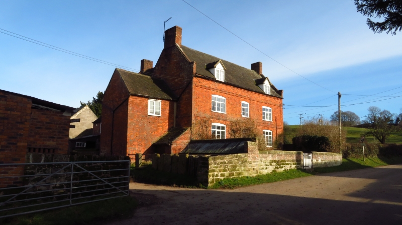
Enson Farmhouse
SJ 92 NW 16/5
II
2.
C18. Brick with tiled roof and end brick stacks; coped gables; modillion
eaves cornice; flat stringcourse between storeys; 2 storeys and attic;
casement windows; 3 window front with 2 gabled dormers; panelled door.
Listing NGR: SJ9408328887
External links are from the relevant listing authority and, where applicable, Wikidata. Wikidata IDs may be related buildings as well as this specific building. If you want to add or update a link, you will need to do so by editing the Wikidata entry.


Other nearby listed buildings
