Approximate Location Map
Large Map »
Latitude: 52.0859 / 52°5'9"N
Longitude: -2.0501 / 2°3'0"W
OS Eastings: 396660
OS Northings: 243065
OS Grid: SO966430
Mapcode National: GBR 2K1.4HB
Mapcode Global: VHB0R.FT1S
Plus Code: 9C4V3WPX+9W
Entry Name: Windrush
Listing Date: 3 August 1972
Grade: II
Source: Historic England
Source ID: 1259868
English Heritage Legacy ID: 443574
ID on this website: 101259868
Location: Little Comberton, Wychavon, Worcestershire, WR10
County: Worcestershire
District: Wychavon
Civil Parish: Little Comberton
Traditional County: Worcestershire
Lieutenancy Area (Ceremonial County): Worcestershire
Church of England Parish: Elmley Castle with Netherton, Bricklehampton, Gt Combrton and Lt Comberton
Church of England Diocese: Worcester
Tagged with: Building Thatched building
LITTLE COMBERTON LITTLE COMBERTON
1.
2301
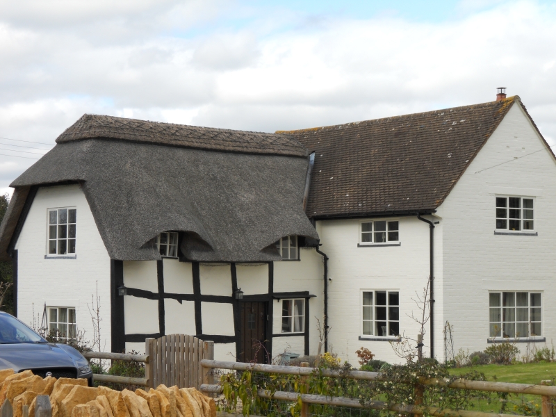
Windrush
SO 94 SE 14/245
II
2.
C17. Timber frame and whitened brick. 2-storeys, Casements. 2 dormers
flush with front. Thatched roof. Larger modern wing.
Listing NGR: SO9666043065
External links are from the relevant listing authority and, where applicable, Wikidata. Wikidata IDs may be related buildings as well as this specific building. If you want to add or update a link, you will need to do so by editing the Wikidata entry.


Other nearby listed buildings
