Approximate Location Map
Large Map »
Latitude: 52.8233 / 52°49'23"N
Longitude: -1.252 / 1°15'7"W
OS Eastings: 450499
OS Northings: 325346
OS Grid: SK504253
Mapcode National: GBR 8JZ.VPV
Mapcode Global: WHDHH.Q9ZF
Plus Code: 9C4WRPFX+85
Entry Name: Stable Block at the Hall
Listing Date: 13 October 1966
Grade: II
Source: Historic England
Source ID: 1260052
English Heritage Legacy ID: 441767
ID on this website: 101260052
Location: Sutton Bonington, Rushcliffe, Nottinghamshire, LE12
County: Nottinghamshire
District: Rushcliffe
Civil Parish: Sutton Bonington
Traditional County: Nottinghamshire
Lieutenancy Area (Ceremonial County): Nottinghamshire
Church of England Parish: Sutton Bonington
Church of England Diocese: Southwell and Nottingham
Tagged with: Stable
SK 52 NW
4/102
13.10.66
SUTTON BONINGTON
MAIN STREET
(east side)
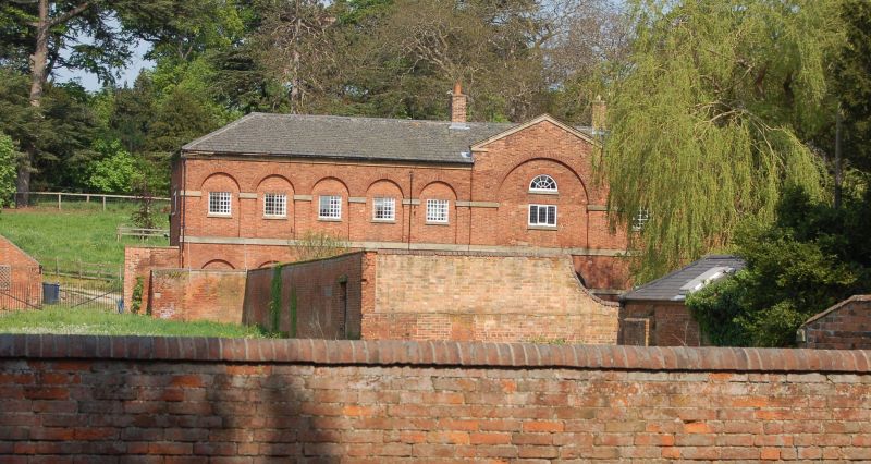
Stable block at The Hall
G.V.
II
Stable block. Late C18. Red brick with ashlar dressings.
Hipped slate roof. 2 red brick ridge stacks. Ashlar cornice.
First floor ashlar band. 2 storeys, 11 bays of round headed
arcading with ashlar imposts. The single central 2 storey plus
attic bay slightly projects, is wider and is topped with an open
ashlar pediment. Central large elliptical arched doorway with
double wooden doors and ashlar hinge blocks. Either side are 2
round arched glazing bar casements. Further left and right are
single doorways with plank door to the left with round arched
over panel and panelled door to the right with fanlight. Further
left and right are 2 similar glazing bar casements. Above are 10
glazing bar casements under flat heads, the single central bay
with part blocked doorway with ashlar hinge blocks and now with
single tripartite glazing bar Yorkshire sash. Above is a single
semi-circular glazing bar fixed light.
Listing NGR: SK5049925346
External links are from the relevant listing authority and, where applicable, Wikidata. Wikidata IDs may be related buildings as well as this specific building. If you want to add or update a link, you will need to do so by editing the Wikidata entry.


Other nearby listed buildings
