Approximate Location Map
Large Map »
Latitude: 53.3905 / 53°23'25"N
Longitude: -2.047 / 2°2'49"W
OS Eastings: 396971
OS Northings: 388188
OS Grid: SJ969881
Mapcode National: GBR GY47.M9
Mapcode Global: WHBB4.J1GL
Plus Code: 9C5V9XR3+66
Entry Name: Outbuildings Immediately South East of Old Hall Farmhouse
Listing Date: 20 December 1967
Last Amended: 11 October 1985
Grade: II
Source: Historic England
Source ID: 1260117
English Heritage Legacy ID: 441666
ID on this website: 101260117
Location: Mellor, Stockport, Greater Manchester, SK6
County: Stockport
Electoral Ward/Division: Marple North
Parish: Non Civil Parish
Built-Up Area: Marple
Traditional County: Derbyshire
Lieutenancy Area (Ceremonial County): Greater Manchester
Church of England Parish: Mellor
Church of England Diocese: Chester
SJ 98 NE MARPLE OLD HALL LANE
(south side)
Near Roman Lakes
7/125 Outbuildings
immediately
south-east of
Old Hall Farmhouse
(formerly listed
as Outbuildings
20.12.67 at Bottoms Hall)
G.V. II
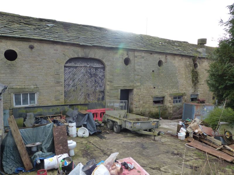
Farmbuildings and mill apprentices dormitory block. 1790s
and C19. Built for Samuel Oldknow. Dressed stone, random
stone with graduated stone slate and corrugated iron roofs.
Long range of buildings forming an S shape, all of 2 storeys
and enclosing a midden. East wing houses pigs on the ground
foor with haylofts above: 12 bays with stone plinth,
continuous first floor band, doors in bays 1 and 12, a
series of semi-circular openings between flat pilasters,
circular first floor pitching eyes and a pointed arch
opening to the gable. The pitching eyes continue on the
middle range which also has opposed cart entries with
flattened elliptical rusticated keystone arch, 2 blocked
cart entries, a driftway and a 3 x 1 haybarn with pointed
arch gable openings and semi-circular arch side openings.
The west wing houses apprentices dormitories on 2 levels
beneath a mono-pitched roof.Total of 7 windows, a band and a
door approached by a flight of steps. The machinery was
formerly powered by waterwheel which still exists in the
adjoining field.
Listing NGR: SJ9697188188
External links are from the relevant listing authority and, where applicable, Wikidata. Wikidata IDs may be related buildings as well as this specific building. If you want to add or update a link, you will need to do so by editing the Wikidata entry.


Other nearby listed buildings
