Approximate Location Map
Large Map »
Latitude: 51.2777 / 51°16'39"N
Longitude: 1.0787 / 1°4'43"E
OS Eastings: 614816
OS Northings: 157672
OS Grid: TR148576
Mapcode National: GBR TY2.X46
Mapcode Global: VHLGM.N43W
Plus Code: 9F3373HH+3F
Entry Name: 40, St Margaret's Street
Listing Date: 3 May 1967
Last Amended: 7 September 1973
Grade: II
Source: Historic England
Source ID: 1260146
English Heritage Legacy ID: 441210
ID on this website: 101260146
Location: Canterbury, Kent, CT1
County: Kent
District: Canterbury
Electoral Ward/Division: Westgate
Parish: Non Civil Parish
Built-Up Area: Canterbury
Traditional County: Kent
Lieutenancy Area (Ceremonial County): Kent
Tagged with: Building
1.
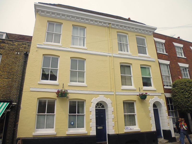
944 ST MARGARET'S STREET
(North West Side)
No 40
(formerly listed as Nos 39 & 40)
TR 1457 NE 4/203 3.5.67.
II GV
2.
Early C19. 3 storeys and basement painted brick. Half-hipped old tiled roof.
Wide wooden bracket cornice. 4 cambered C19 sashes. 2 stringcourses. Plinth.
2 round-headed doorcases with quoined surrounds. Semi-circular fanlight.
Left side doorcase has 6 fielded panels. Right side has 4 ordinary panels.
Nos 38 to 42 (consec) form a group.
Listing NGR: TR1481957692
External links are from the relevant listing authority and, where applicable, Wikidata. Wikidata IDs may be related buildings as well as this specific building. If you want to add or update a link, you will need to do so by editing the Wikidata entry.


Other nearby listed buildings
