Approximate Location Map
Large Map »
Latitude: 54.2369 / 54°14'12"N
Longitude: -0.7138 / 0°42'49"W
OS Eastings: 483926
OS Northings: 483123
OS Grid: SE839831
Mapcode National: GBR RMGF.8Y
Mapcode Global: WHGC2.0RCR
Plus Code: 9C6X67PP+QF
Entry Name: Church Farmhouse and Attached Cottage
Listing Date: 5 February 1986
Grade: II
Source: Historic England
Source ID: 1260621
English Heritage Legacy ID: 440224
ID on this website: 101260621
Location: Thornton-le-Dale, North Yorkshire, YO18
County: North Yorkshire
District: Ryedale
Civil Parish: Thornton-le-Dale
Built-Up Area: Thornton-le-Dale
Traditional County: Yorkshire
Lieutenancy Area (Ceremonial County): North Yorkshire
Tagged with: Farmhouse
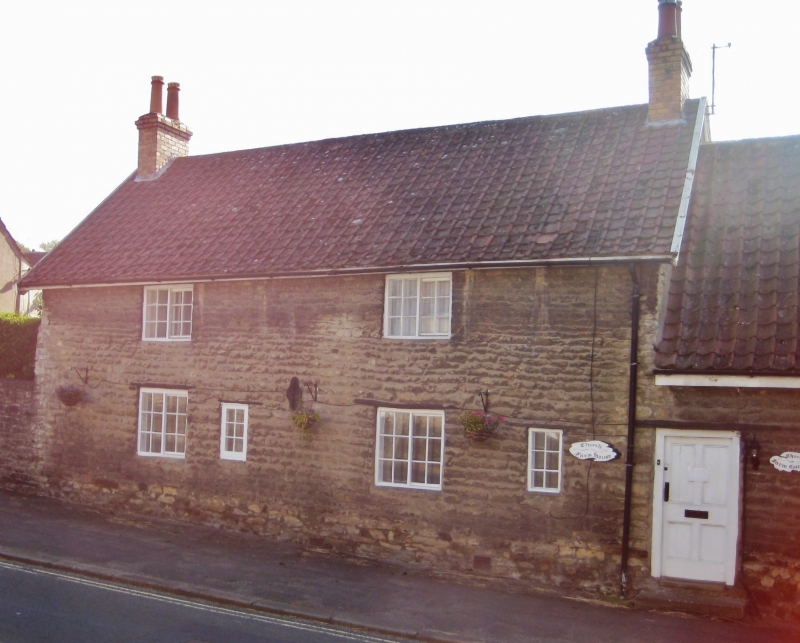
THORNTON DALE HIGH STREET
SE 8383
(south side)
14/117 Church Farmhouse and
attached cottage
GV II
House and attached byre; now house and cottage. C17; raised, subdivided and
extended C20. Coursed limestone rubble; French tile roof; rebuilt brick
stacks. Originally 3-cell, through-passage plan; service wing at left rear
added. 2-storey, 2-window high end to left, with single storey low end.
4-panel door to low end, at left. High end windows are 2-light small-pane
horizontal sliding sashes to both floors, with fixed-light fire window to
ground floor right and similar small window to left of centre. Windows to
low end are C20 insertions. Thin timber lintels to all openings. End
stacks to high end. Interior: two pairs of full, jointed crucks with
collars and apex saddles survive in the cross walls of the rooms to left and
right of the through passage. Bressummer beam in first room to left is a
re-used cruck blade. Low C18 panelled door with H-L hinges to ground floor
end room to left.
Listing NGR: SE8392683123
External links are from the relevant listing authority and, where applicable, Wikidata. Wikidata IDs may be related buildings as well as this specific building. If you want to add or update a link, you will need to do so by editing the Wikidata entry.


Other nearby listed buildings
