Approximate Location Map
Large Map »
Latitude: 50.9491 / 50°56'56"N
Longitude: -2.7151 / 2°42'54"W
OS Eastings: 349862
OS Northings: 116878
OS Grid: ST498168
Mapcode National: GBR MK.NHY5
Mapcode Global: FRA 566L.N2V
Plus Code: 9C2VW7XM+MX
Entry Name: Montacute Baptist Church, and Front Boundary Wall and Railings
Listing Date: 27 October 1987
Grade: II
Source: Historic England
Source ID: 1261601
English Heritage Legacy ID: 437115
ID on this website: 101261601
Location: Montacute, Somerset, TA15
County: Somerset
District: South Somerset
Civil Parish: Montacute
Built-Up Area: Montacute
Traditional County: Somerset
Lieutenancy Area (Ceremonial County): Somerset
Tagged with: Architectural structure
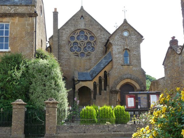
ST4916 MONTACUTE CP SOUTH STREET (East side)
8/174 Montacute Baptist Church, and
front boundary wall and railings
-
GV II
Baptist Church. 1879, by Morgan H. Davies. Ham stone ashlar; Welsh slate roof between coped gables. In an Early English
style, with gable ends to road. Plinth: main gable features a Geometric rose window under trefoil gable vent, with a
cusped label in pointed segmental-arched recess below left: on south-west corner a quasi-turret with gable end having
segmental- arched doorway flanked by Gothic foliated capital shafts under label roll, above which is a rather wide
cusped lancet and a clock-face in the gable; across main gable and in angle formed by projecting turret, leading to
first floor of same, an open covered stair with pitched Welsh slate roof and arches and pillars to match doorway: cast
iron finials to both gables. C20 chimney stack to north-west corner. Foundation stone with date and architect's name on
front wall. South side elevation has 4 pairs pointed segmental-arched windows under continuous label. Attached to rear
a 7 bay schoolroom block, sash windows below and semi-circular arched casements above under continuous arched label.
Further extension to east. Interior not seen. About 10 metres west the front boundary wall, ashlar with plinth and
angled coping, with square piers having frieze bands and bell- hip caps: railings with taper points to middle and top
rails, fleur-de-lys tops to arch-braced standards, matching gates, adding to setting of Church.
Listing NGR: ST4986216878
External links are from the relevant listing authority and, where applicable, Wikidata. Wikidata IDs may be related buildings as well as this specific building. If you want to add or update a link, you will need to do so by editing the Wikidata entry.


Other nearby listed buildings
