Latitude: 51.0375 / 51°2'15"N
Longitude: -4.1371 / 4°8'13"W
OS Eastings: 250261
OS Northings: 128638
OS Grid: SS502286
Mapcode National: GBR KM.GXDG
Mapcode Global: FRA 267C.L36
Plus Code: 9C3Q2VQ7+25
Entry Name: Pyewell Farmhouse, Including Adjoining Granary and Stables at Left End
Listing Date: 29 May 1986
Last Amended: 18 March 1987
Grade: II
Source: Historic England
Source ID: 1261776
English Heritage Legacy ID: 436725
ID on this website: 101261776
Location: Horwood, North Devon, EX39
County: Devon
District: North Devon
Civil Parish: Horwood, Lovacott and Newton Tracey
Traditional County: Devon
Lieutenancy Area (Ceremonial County): Devon
Church of England Parish: Fremington St Peter
Church of England Diocese: Exeter
Tagged with: Agricultural structure
NEWTON TRACEY SS 52 NW 4/11 Pyewell Farmhouse, including - adjoining granary and stables at left end (formerly listed under the parish of Fremington) 29.5.86
- II
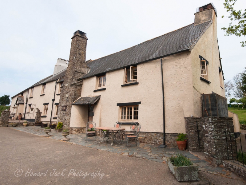
Farmhouse with granary and stables attached. Farmhouse early C16, remodelled probably in Cl7 and again circa 1710. Stables and granary added probably in late C18/early C19. Rendered stone rubble and cob. Slate roofs with gabled ends. Farmhouse has rendered axial stack heating inner room, stack at right gable end heating lower end, and tall stone rubble lateral hall stack with tapered cap and offsets. Through-passage former open hall house plan, consisting originally of hall and lower end, the solid cob partition between hall and inner room rising to the apex of the roof suggesting latter was an early C18 addition, when a dairy was also added beyond the inner room. Stables and granary also added at this upper end. 2 storeys. Farmhouse has 5-window range. C20 fenestration. 2-light casements, except for one 3-light casement at lower end. Slate canopy to through-passage doorway. External stone steps to granary plank door with loft door over plank door to left and double plank door to right. Interior: A single smoke-blackened raised cruck truss survives over the hall with trenched purlins, and though the 2 trusses with lap-jointed collars over the lower end appear to have been replaced possibly in early C18, it is possible this end was always ceiled, with large scroll stops to the single ceiling beam. The hall ceiling beam and bressumers have decorative foliated stops with chamfered fireplace lintel. There is no access to roofspace over upper end, but the height of the ceiling and feet of the trusses with part of moulded plasterwork cornice surviving at each end suggests this end may have been added in 1710, the date over the doorway to dairy, now concealed and doorway blocked. Stair turret to rear of the parlour has dog-leg staircase with bobbin-turned balusters and square newels with clasping barley sugar balusters at the corners. 6 panelled door to doorway at head of stairs.
Listing NGR: SS5026128638
External links are from the relevant listing authority and, where applicable, Wikidata. Wikidata IDs may be related buildings as well as this specific building. If you want to add or update a link, you will need to do so by editing the Wikidata entry.


Other nearby listed buildings