Approximate Location Map
Large Map »
Latitude: 52.5836 / 52°35'0"N
Longitude: -2.1485 / 2°8'54"W
OS Eastings: 390037
OS Northings: 298428
OS Grid: SO900984
Mapcode National: GBR 17L.V7
Mapcode Global: WHBFY.ZB26
Plus Code: 9C4VHVM2+CJ
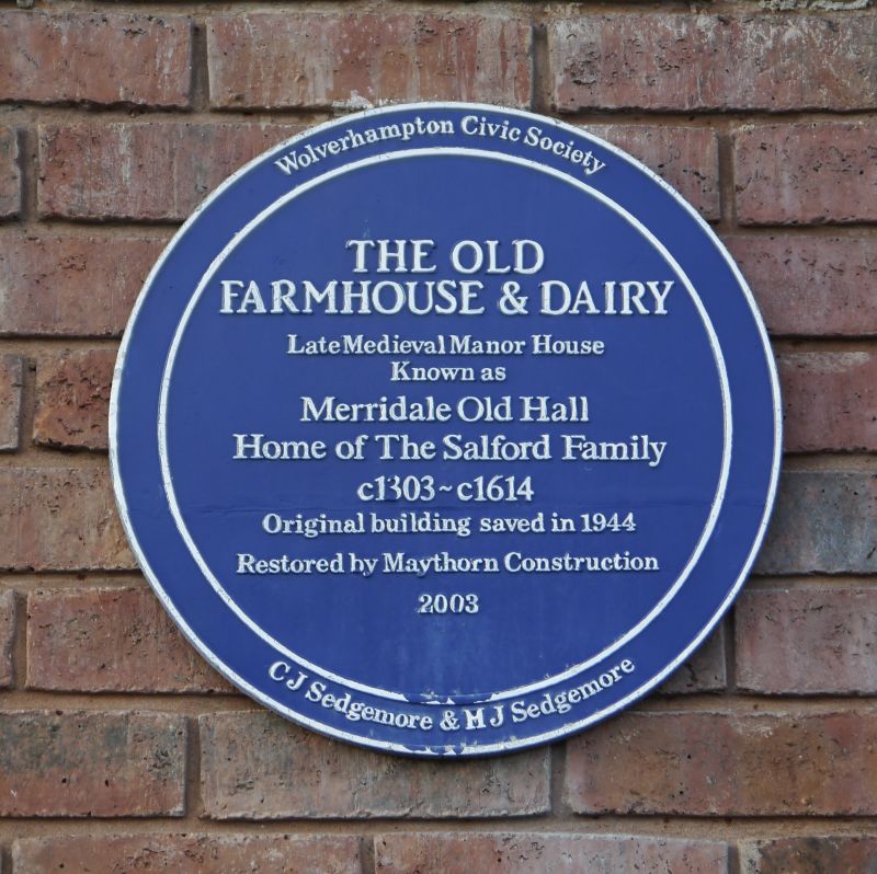
Entry Name: The Old Farmhouse and Dairy
Listing Date: 11 April 1995
Grade: II
Source: Historic England
Source ID: 1262153
English Heritage Legacy ID: 435698
ID on this website: 101262153
Location: Merridale, Wolverhampton, West Midlands, WV3
County: City of Wolverhampton
Electoral Ward/Division: Park
Parish: Non Civil Parish
Built-Up Area: Wolverhampton
Traditional County: Staffordshire
Lieutenancy Area (Ceremonial County): West Midlands
Church of England Parish: Wolverhampton St Jude
Church of England Diocese: Lichfield
SO 99 NW WOLVERHAMPTON MERRIDALE LANE
Merridale
895-1/5/10014
The Old Farrmhouse and Dairy
II
House, subdivided. Late Medieval; remodelled circa early C17, extended circa C18 and with C20 alterations. Timber-framed, partly rebuilt and extended in brick, now all rendered. Gable-ended roof: cladding stripped off Truncated axial, lateral and gable-end brick stacks. PLAN: Hall and cross-wing; the cross-wing on the right [north] is late Medieval, its first floor was jettied on three sides and its ground floor divided into two rooms, the larger at the front.
The main range was probably the site of the Medieval hall, rebuilt with two storeys and an attic in circa early C17 probably when the first floor of the cross-wing was rebuilt. In about the C18 the walls of the hall range were rebuilt in brick, a 1-storey and attic 1-bay range was added at the left [south] end and a stair tower was built in the angle of the cross-wing at the rear. The wing behind the cross-wing is probably also C18. In the C20 the cross-wing jetties were underbuilt and three shop fronts were inserted at the front. EXTERIOR: 2 storey and attic and 1 storey and attic. Asynunetrical3-window east front, to right projecting gabled cross-wing, to left l-storey and attic. C20 3-1ight casements and flat-roof dormers. Three C20 shop fronts on ground floor. At the rear gabled cross-wing on left, gabled stair tower in the angle and lower gable-ended wing projecting from cross-wing. INTERIOR: Cross-wing: timber-frame
partition wall; front and back rooms have dragon beams, chamfered axial and cross-beams with step stops and unchamfered joists; chambers above have chamfered cross-beams and unchamfered joists. Main south range: former hall has chamfered axial beam with ogee stops and unchamfered joists; hall chamber above also has chamfered axial beam with ogee stops; exposed in attic chamber above large purlins. Rear wing has chamfered cross-beam with waney end and unchamfered joists. HISTORICAL NOTE: It was the home of the de Salfords family and there are references to the de Salfords of Merridale from the early C14. SOURCES:
Mander, G.P. History of Wolverhampton to Early Nineteenth Century. West Midlands SMR. RCHME report no.93353.
Listing NGR: SO9155198987
External links are from the relevant listing authority and, where applicable, Wikidata. Wikidata IDs may be related buildings as well as this specific building. If you want to add or update a link, you will need to do so by editing the Wikidata entry.


Other nearby listed buildings
