Approximate Location Map
Large Map »
Latitude: 55.0154 / 55°0'55"N
Longitude: -2.1312 / 2°7'52"W
OS Eastings: 391710
OS Northings: 568995
OS Grid: NY917689
Mapcode National: GBR FBKF.DX
Mapcode Global: WHB25.76FF
Plus Code: 9C7V2V89+5G
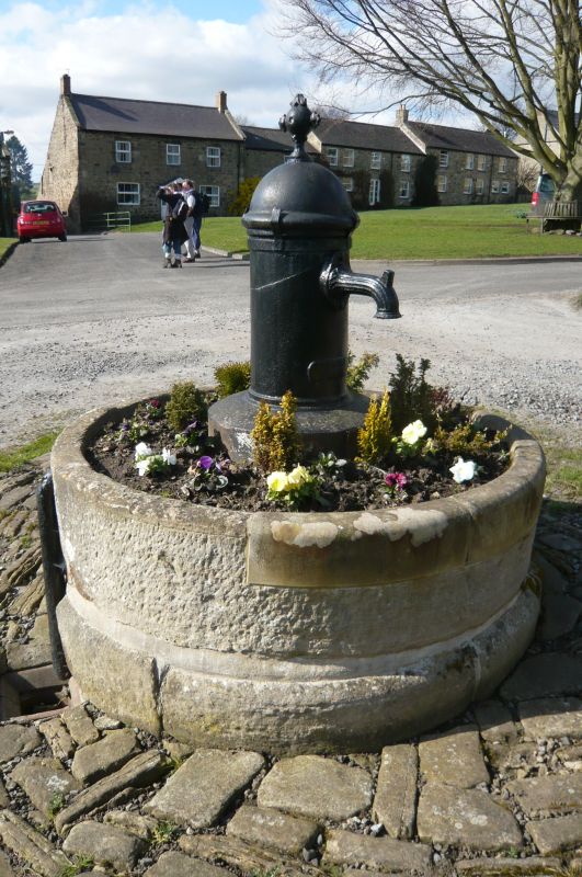
Entry Name: Hydrant and Trough
Listing Date: 15 April 1969
Last Amended: 24 May 1988
Grade: II
Source: Historic England
Source ID: 1262956
English Heritage Legacy ID: 433602
ID on this website: 101262956
Location: Wall, Northumberland, NE46
County: Northumberland
Civil Parish: Wall
Traditional County: Northumberland
Lieutenancy Area (Ceremonial County): Northumberland
Church of England Parish: St Oswald-in-Lee with Bingfield
Church of England Diocese: Newcastle
Tagged with: Fire hydrant
WALL THE GREEN
NY 9168 (Centre)
Wall Village
17/363 Hydrant and trough
15.4.69 (previously listed as
GV Village Spring on Green)
II
Hydrant and trough, dated July 29 1858. Cast iron, stone. Hydrant has domed
top with ornamental finial and fluted spout above dated plate, set on plinth in
centre of circular stone trough on chamfered base course.
Listing NGR: NY9171068995
External links are from the relevant listing authority and, where applicable, Wikidata. Wikidata IDs may be related buildings as well as this specific building. If you want to add or update a link, you will need to do so by editing the Wikidata entry.


Other nearby listed buildings
