Approximate Location Map
Large Map »
Latitude: 51.1355 / 51°8'7"N
Longitude: 0.2604 / 0°15'37"E
OS Eastings: 558237
OS Northings: 139791
OS Grid: TQ582397
Mapcode National: GBR MPS.LNM
Mapcode Global: VHHQD.GQHC
Plus Code: 9F3247P6+64
Entry Name: 42, Mount Ephraim
Listing Date: 7 June 1974
Grade: II
Source: Historic England
Source ID: 1266268
English Heritage Legacy ID: 168078
ID on this website: 101266268
Location: Royal Tunbridge Wells, Tunbridge Wells, Kent, TN4
County: Kent
District: Tunbridge Wells
Electoral Ward/Division: Culverden
Parish: Non Civil Parish
Built-Up Area: Royal Tunbridge Wells
Traditional County: Kent
Lieutenancy Area (Ceremonial County): Kent
Church of England Parish: Tunbridge Wells St John
Church of England Diocese: Rochester
Tagged with: Building
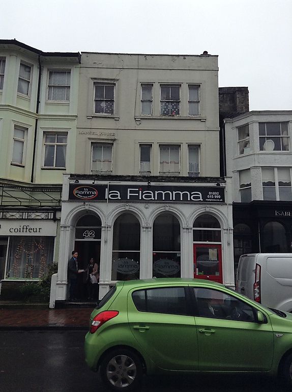
MOUNT EPHRAIM
1.
1746 (North West Side)
No 42
TQ 5839 NW 3/266
II GV
2.
Mid C19. 3 storeys stuccoed. Brick on side elevation. Parapet stringcourses.
1 sash set in moulded architrave and 1 3-light sash. Interesting late C19 projecting
shop front with 4 round-headed arches which incorporate a doorcase supported on
slender pilasters.
Nos 38 to 42 (even) form a group.
Listing NGR: TQ5822939793
External links are from the relevant listing authority and, where applicable, Wikidata. Wikidata IDs may be related buildings as well as this specific building. If you want to add or update a link, you will need to do so by editing the Wikidata entry.


Other nearby listed buildings
