Approximate Location Map
Large Map »
Latitude: 51.7977 / 51°47'51"N
Longitude: -0.0844 / 0°5'3"W
OS Eastings: 532194
OS Northings: 212744
OS Grid: TL321127
Mapcode National: GBR KBQ.9GK
Mapcode Global: VHGPN.H27P
Plus Code: 9C3XQWX8+36
Entry Name: Folly in Grounds of Beane River View (Beane River View Not Included)
Listing Date: 9 September 1996
Grade: II
Source: Historic England
Source ID: 1268777
English Heritage Legacy ID: 461450
ID on this website: 101268777
Location: Hertford, East Hertfordshire, SG14
County: Hertfordshire
District: East Hertfordshire
Civil Parish: Hertford
Built-Up Area: Hertford
Traditional County: Hertfordshire
Lieutenancy Area (Ceremonial County): Hertfordshire
Church of England Parish: Bengeo Holy Trinity and St Leonard with Christ Church
Church of England Diocese: St.Albans
Tagged with: Folly
HERTFORD
TL3212NW PORT VALE
817-1/16/171 (South side)
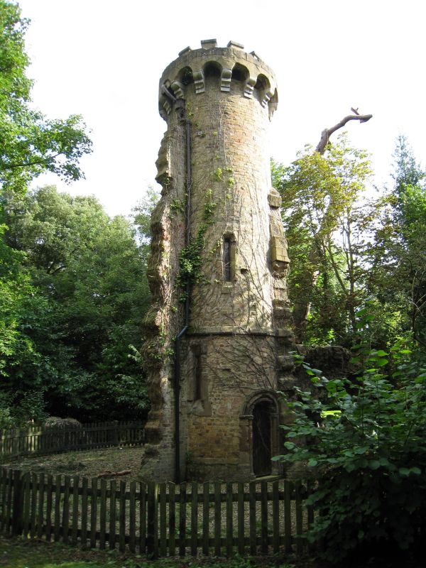
Folly in grounds of Beane River View
(Beane River View not included)
II
Folly. c1848. Yellow stock brick with stone and artificial
stone dressings. Neo-Romanesque style, built as ornamental
ruin.
3 storey circular tower with machicolated top and projecting
Lombard frieze. Slit windows with artificial stone heads,
quoins and sills. Buttresses to suggest 'ruined' walls; ground
floor has semicircular headed Norman style doorway with
cushion capitals on colonnettes and rope moulded head.
To west is single storey continuation in rubble and artificial
stone with external stair to first floor running over
elaborate Norman style semicircular archway with triple
colonnette reveals, cushion capitals, moulded impost band and
twine and ball, dog tooth and bird beak moulded bands below
outer dripmould.
HISTORICAL NOTE: this folly was built in the extended garden
area of No.2 North Road (qv), acquired by Thomas Smith in the
1840s, which included 5 acres of picturesque gardens, and the
island between the river and the Sele Mill stream. Ownership
was split after 1945 and the folly is now in the grounds of a
recently developed sheltered housing and nursing home for the
elderly.
(Felstead A: Directory of British Architects 1834-1900:
London: 1993-).
Listing NGR: TL3219412744
External links are from the relevant listing authority and, where applicable, Wikidata. Wikidata IDs may be related buildings as well as this specific building. If you want to add or update a link, you will need to do so by editing the Wikidata entry.


Other nearby listed buildings
