Approximate Location Map
Large Map »
Latitude: 51.7975 / 51°47'50"N
Longitude: -0.0795 / 0°4'46"W
OS Eastings: 532534
OS Northings: 212725
OS Grid: TL325127
Mapcode National: GBR KBQ.BQB
Mapcode Global: VHGPN.K2VW
Plus Code: 9C3XQWWC+X6
Entry Name: Old Cross Wharf
Listing Date: 9 September 1996
Grade: II*
Source: Historic England
Source ID: 1268795
English Heritage Legacy ID: 461426
ID on this website: 101268795
Location: Hertford, East Hertfordshire, SG14
County: Hertfordshire
District: East Hertfordshire
Civil Parish: Hertford
Built-Up Area: Hertford
Traditional County: Hertfordshire
Lieutenancy Area (Ceremonial County): Hertfordshire
Church of England Parish: Hertford St Andrew with St Nicholas
Church of England Diocese: St.Albans
Tagged with: Architectural structure
HERTFORD
TL3212NE OLD CROSS
817-1/17/151 (North side)
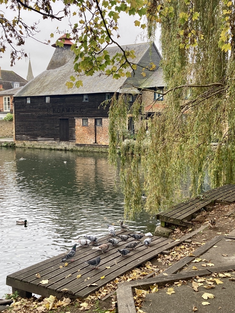
Old Cross Wharf
GV II*
Former maltings, kiln, grain store, cart shed and tally house,
now seed and feed warehouse. Late 18th and early C19 (but with
C16 red brick at base of malthouse). Timber-framed and
cast-iron structure, yellow stock brick,laid to English and
Flemish bonds, with some red brick part weatherboards. Old
tiled, pantiled and Welsh slated roofs with lead-roll hips.
Conical kiln roof at south east corner with double mushroom
cowls.
EXTERIOR: SOUTH RANGE: fronting Nicholas Lane, 2 storeys and
attics; 11-bay structure (with 2 incomplete bays at left) with
kiln at right on river frontage, pilaster buttresses at bay
lines in centre of range, connected by segmental arches below
eaves. Ground floor openings have segmental soldier arches,
central loading bay with first floor hoist balcony and
cantilevered gable roof. Gambrel roof with lower slopes
slated, hipped left (west) end upper roof tiled on west and
north faces, and with corrugated asbestos, replacing tiles
after 1944 wartime damage. C19 hip roofed lean-to on yard
(north) side, with red brick walls, and blank weatherboard
cladding above. Kiln at right-hand (east end) has brickwork
strengthened with 6 iron tie plates at first-floor level,
marked 'Goodfellow. Ware.'. Return frontage north along river
timber-framed and black weatherboarded.
EAST RANGE: C19 grain store has 11-bay front to river, with 2
openings to ground and first floors alternating with full
length doors on both floors to expedite loading from the
wharf. Welsh slated roofs. Similar pattern of openings to
yard.
NORTH RANGE: former stables, first floor with 4 openings,
central stable door with loft opening above, ground floor has
two 6-pane sash windows with double header segmental arches
above, and boarded coach doors at right beneath 3 ring header
segmental arches.
CART SHED: against west boundary, red brick, laid to Flemish
bond, 2 open bays, Queen strut trussed pantiled roof.
TALLY HOUSE: c1830, single storey with mixed red and yellow
stock bricks, Flemish bond, with Welsh slated roof with
lead-roll hips over 2 planed flat overhanging soffit, 6-pane
sash window at left under segmental arch, half-glazed door
beneath open pediment hood carried on cut bracket modillions.
East end of building has large canted bay window overlooking
yard, and entrance from street, 6 pane sidelights with arcaded
heads, 10-pane centre with casements either side of fixed
6-pane light, ogee moulding and flat fascia above.
INTERIOR: SOUTH RANGE: timber baulks and cast-iron columns
support rafters coach-nailed to diagonal beams, much re-used
riven timber, Queen strut roof timber partly removed after
wartime damage, wooden sack hoist at north end. Kiln
substantially intact, 3 vaulted brick furnaces with wire grid
floors above, lath and plaster timber studded kiln chimney
with mesh drying floor. Beyond kiln end of building is at an
angle to river and the wall of the building is timber-framed
incorporating late C17 studs and primary bracing.
EAST RANGE: subdivision into 3 bay compartments by brick cross
walls, with heavy square binders with common joists spanning
between, tongued and grooved board floors with iron tongues.
King post roof with 2 levels of purlins.
NORTH RANGE: 2 stalls with peg-jointed divisions numbered with
carpenters' marks, feed troughs and tethering rings, loft
divided into two 3 bay sections by cross walls, King post and
purlin roof.
HISTORICAL NOTE: although disused as a maltings since the
Second World War, Old Cross Wharf remains virtually intact,
with its buildings in use for the storage of agricultural
feedstuffs and seeds. The traces of C16 brick mark it out as
one of the earliest malting sites in Hertford albeit that the
buildings largely date from late C18/early C19. The wharf and
the grouping facing the River Lea with the kiln roof and cowl
in the south-east corner, is of significant townscape value.
(The industrial archaeology of the British Isles: Branch
Johnson W: Industrial Archaeology of Hertfordshire: Newton
Abbot: 1970-: 37, 167).
Listing NGR: TL3253412724
External links are from the relevant listing authority and, where applicable, Wikidata. Wikidata IDs may be related buildings as well as this specific building. If you want to add or update a link, you will need to do so by editing the Wikidata entry.


Other nearby listed buildings
