Approximate Location Map
Large Map »
Latitude: 51.5811 / 51°34'51"N
Longitude: -2.0957 / 2°5'44"W
OS Eastings: 393467
OS Northings: 186918
OS Grid: ST934869
Mapcode National: GBR 2QZ.YSS
Mapcode Global: VH95S.MJG9
Plus Code: 9C3VHWJ3+CP
Entry Name: 125, High Street
Listing Date: 6 August 1974
Last Amended: 19 July 1996
Grade: II
Source: Historic England
Source ID: 1269328
English Heritage Legacy ID: 460866
ID on this website: 101269328
Location: Burton Hill, Wiltshire, SN16
County: Wiltshire
Civil Parish: Malmesbury
Built-Up Area: Malmesbury
Traditional County: Wiltshire
Lieutenancy Area (Ceremonial County): Wiltshire
Church of England Parish: Malmesbury and Brokenborough
Church of England Diocese: Bristol
Tagged with: Building
MALMESBURY
ST9386 HIGH STREET
758-1/3/203 (South side)
06/08/74 No.125
(Formerly Listed as:
HIGH STREET
(South side)
Nos.87-103, 107, 113-137 (Odd))
GV II
Formerly known as: Nos.125-131 HIGH STREET.
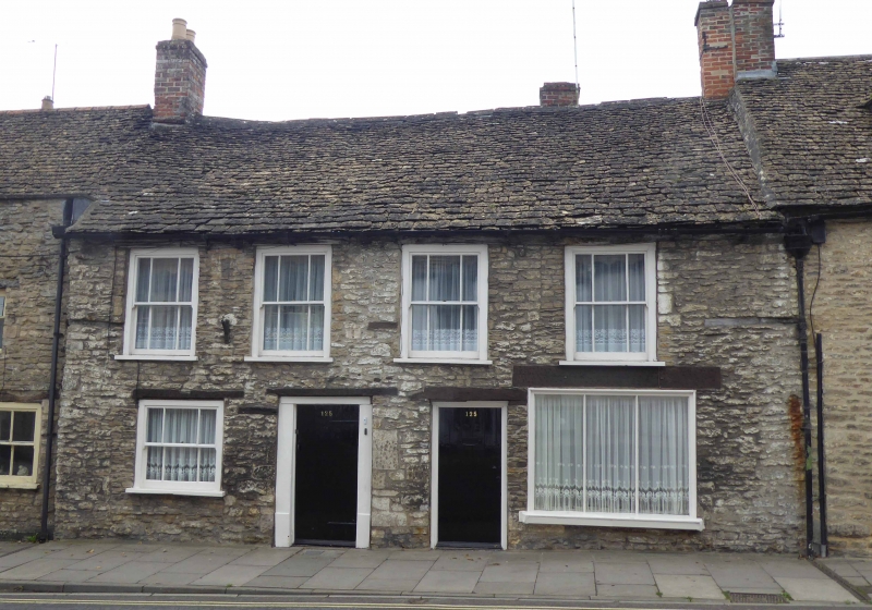
House, extended, divided into 4, now one. Early C17, extended
mid C17, refronted, roof raised; extended to rear late C18.
Limestone rubble with brick lateral and gable stacks and stone
slate roof.
PLAN: L-plan, a 2-room parallel range with a through-passage,
mid C17 right-hand rear wing and C18 left-hand rear service
wing.
EXTERIOR: 2 storeys and attic; 4-window range. Timber lintels
to openings, 2 central doorways with boarded doors, the
left-hand one with a wide C18 frame and 3-plank door to the
through-passage, a right-hand former shop window with 3
plate-glass panes, left-hand ground-floor window with brick
infill to side and below, with wide plate-glass sashes with
margin bars in exposed boxes. Sections of former wall plate
flank first-floor windows.
The through-passage is flagged with timber square framing with
brick noggingg, and doorways each side to the front.
Rear 2-window range has an inserted stack toward the rear; a
blocked doorway to the left of the current doorway at the rear
end of the passage, a C17 3-light pegged timber mullion
windows with iron casements, and the gable has a ground-floor
10/10-pane sash. Brick C18 wing has a well.
INTERIOR: details of the front range include a timber-framed
through-passage, the right-hand room has a bressumer to a
rubble hearth with parts of a former winder stair to the left,
now a doorway, with wide chamfers to beams and wall plate,
first-floor with a 3-bay roof with early C17 truss blades with
trenched purlins to extended C18 tie beams.
The rear wing has thick walls, splayed window reveals with
seats, and chamfered, stopped beams; the roof largely rebuilt
C19, has a C17 truss behind the stack that backs onto the
front range, possibly from a smoke bay.
Listing NGR: ST9347286908
External links are from the relevant listing authority and, where applicable, Wikidata. Wikidata IDs may be related buildings as well as this specific building. If you want to add or update a link, you will need to do so by editing the Wikidata entry.


Other nearby listed buildings
